
|
| POLSKA | POLAND |
| województwo: Śląskie | voivodship: Silesia |
| miasto na prawach powiatu: Mysłowice | city: Mysłowice |
 Mysłowice is situated at an elevation of 274 m in the Silesian Highlands, on the Przemsza and Brynica rivers (tributaries of the Vistula),
about 9 km east of Katowice, the capital of the voivodship Silesia. The municipality has a population of
about 74,900 (2010).
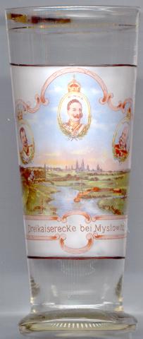
Mysłowice is one of the oldest towns in Upper Silesia. Located at the confluence of the rivers White and Black Przemsza it was situated at an important trading path from Wrocław to Kraków. The earliest traces of the modern settlement date back to the 12th and 13th century. The first mentioning of a parish priest is found in a document of 1306. In 1360 Mysłowice is already mentioned as a town. During the centuries the ownership over the town changed frequently, and so did the borders between the different countries. After the foundation of the German Empire in 1871 the area became known as "Dreikaiserecke" [as inscribed on the glass] ("triangle of three emperors") as it was situated at the point where the Austrian, German and Russian Empires adjoined. After World War I and a plebiscite in 1922 Mysłowice and a part of Upper Silesia became part of the newly restored Poland (see map of Poland 1918/23).
The picture shows the town of Mysłowice (in German: Myslowitz) in the background.
The landscape on the left and the centre background at that time belonged to the
German Empire, the part on the right was part of Russia (today part of the Polish city of Sosnowiec),
and the small part in the foreground right belonged to the Austro-Hungarian Monarchy (today part of the Polish town of
Jaworzno). The three portraits
show the German Emperor Wilhelm II (1859–1941) [centre],
Czar Nikolai II (1868–1918) [left], and
Emperor Franz Joseph I of Austria (1830–1916) [right].
![[scale]](lineal.jpg)