
|
|
| ČESKÁ REPUBLIKA | CZECH REPUBLIC |
| Vysočina | Highlands (Jihlava) region |
| Okres: Pelhřimov |
map →

Křemešník is a mountain in the municipality of Nový Rychnov in the Vysočina (Highlands) Region of the Czech Republic. The mountain lies about 8 km southeast of the district town Pelhřimov and about 20 km west of Jihlava, the administrative and is part of Bohemian-Moravian Highlands. With an elevation of 769 m above sea level, it is the highest mountain of the Křemešník Highlands, which are part of the Bohemian-Moravian Highlands.
 From 1763 onwards, the large pilgrimage to Křemešník united Czechs and Germans from the
neighboring Jihlava (Iglau) area, as well as from Bavaria. Křemešník became the main
pilgrimage site of the Diocese of České Budějovice (Budweis).
After World War II, the pilgrimages were revived. However, after the communist takeover pilgrimages were
forbidden for almost 40 years. After the fall of the communist regime, the pilgrimages were resumed in
1989.
From 1763 onwards, the large pilgrimage to Křemešník united Czechs and Germans from the
neighboring Jihlava (Iglau) area, as well as from Bavaria. Křemešník became the main
pilgrimage site of the Diocese of České Budějovice (Budweis).
After World War II, the pilgrimages were revived. However, after the communist takeover pilgrimages were
forbidden for almost 40 years. After the fall of the communist regime, the pilgrimages were resumed in
1989.
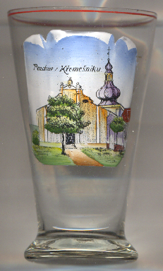
The  pilgrimage church of the Holy Trinity [left, no. 4924]
was built between 1710 and 1720, the cloister was added in 1734. After further expansion, it was consecrated
in 1750.
pilgrimage church of the Holy Trinity [left, no. 4924]
was built between 1710 and 1720, the cloister was added in 1734. After further expansion, it was consecrated
in 1750.
[https://en.wikipedia.org/wiki/K%C5%99eme%C5%A1n%C3%ADk;
https://de.wikipedia.org/wiki/K%C5%99eme%C5%A1n%C3%ADk, https://cs.wikipedia.org/wiki/Kostel_Nejsv%C4%9Bt%C4%9Bj%C5%A1%C3%AD_Trojice_(K%C5%99eme%C5%A1n%C3%ADk)]
![[scale]](lineal.jpg)