
|
| ČESKÁ REPUBLIKA | CZECH REPUBLIC |
| Jihočeský kraj | South Bohemia (České Budějovice) region |
| Okres: České Budějovice |
České Budějovice is situated at an elevation of 378 m at the confluence of the rivers Malše (Maltsch) and Vltava (Moldau).
The town was founded in 1265 by King Přemysl Otakar II in order to strengthen his position in southern Bohemia.
The regular ground plan of the city with its large central square are a masterpiece of medieval planning.
During the Hussite wars of the 15th century, the town remained faithful to the Catholic faith. Due to its strong fortifications it was not even
besieged like so many other towns of the area. During the 16th century, the old trading town grew further due to silver mining, bear brewing,
fish farming and salt trading. During the Thirty Years' War (1618–1648), the town remained faithful to the Emperor, and for a short period of
 time even guarded the Bohemian crown jewels. After a large fire in 1641, which destroyed large parts of the town, the Baroque style
added to the old Renaissance character of the town. During the 18th century, České Budějovice became the centre of the South Bohemian region.
Since 1785 it is the seat of a bishop. The 19th century brought many technical innovations. Europe's first horse carriage railway between
České Budějovice and Linz was constructed between 1825 and 1832.
The Czech brewery, which later became
 world-famous for its Budějovický Budwar (Budweiser Budvar) beer was opened in 1895.
České Budějovice has been selected as one of European Capitals of Culture for 2028 (together with Skopje in North Macedonia and Bourges in France).
[See list of other European Capitals of Culture depicted on glasses of this collection.]
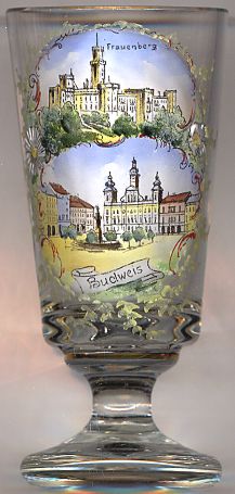
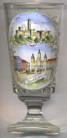
České Budějovice's  central square [foreground] is named after King Přemysl Otakar II
(náměstí Přemysla Otakara II). It is the largest square (1 hectare) in the Czech Republic.
The Baroque  Samson fountain [left] on the square was erected in 1721–1726
in order to supply the city with water from the Vltava river. The sculpture on top of the fountain shows Samson killing a lion.
The  Blach Tower (černa věž) [background] was built between 1550 and 1577. The original use
of the tower (72 m high) was that of a bell and watch tower.
The  church of St. Nicholas (kostel sv. Mikulaše) [background right] was built in the 17th century
after the fire of 1641 had destroyed the original Gothic church. In 1785 it became the cathedral of the newly established diocese of České Budějovice.
The main altar dates from 1741.


The  town hall [left, no. 3878: top picture; right, no. 2574, and bottom right, no. 4868: bottom pictures]
goes back to a Renaissance structure that had been built in the 16th century.
In the first half of the 18th century it was rebuilt in Baroque style by the architect
Antonio E. Matrinelli.

The top pictures on glasses no. 2574 and no. 4868 show a view of the castle of Hluboká nad Vltavou,
located about 10 km north of České Budějovice.
Note: the two glasses on the right are decorated with identical pictures (individually coloured by hand), but they differ in the
language of the labelling:
glass no. 2574 [far right] is labelled in German: Frauenberg and Budweis, while
glass no. 4868 [near right] is labelled in Czech: zámek Hluboká (Hluboká castle) and
Č[eské] Budéjovice.
![[scale]](lineal.jpg)