
|
| ČESKÁ REPUBLIKA | CZECH REPUBLIC |
| Středočeský kraj | Central Bohemia region |
| Okres: Příbram |
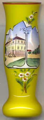
 Sedlec-Prčice is situated at an elevation of 407 m at the confluence of the streams Sedlecký potok and Prčický
potok in the very south of Central Bohemia, about 41&nbsl;km southeast of the district town Přibram and about
59 km south of Prague. The municipality has a population of about 2,900 (2023).
Prčice is the older of the two settlements and already existed in 1184. Prčice is the cradle of the Witigon family and its branches Krumau
(Český Krumlov), Rosenberg (Rožmberk nad Vltavou, Neuhaus
(Jindřichův Hradec) and Landstein (Staré Město pod Landštejnem).
Between 1815 and 1822, a stone bridge was built in place of the swampy ford across the Sedlecký potok between Sedlec and Prčice.
Since Sedlec and Prčice were not connected to the railway network in the 19th century, no industry developed here.
Sedlec obtained the status of a town in the 18th century and since the 19th century was the seat of a district court, while Prčice
had the status of a market town. In 1957, the municipalities of Sedlec and Prčice were merged into a single municipality.
Since 1960, Sedlec-Prčice was placed in the district Benešov until 2006 when it was reallocated to the district
Přibram.
[https://de.wikipedia.org/wiki/Sedlec-Pr%C4%8Dice]
![[scale]](lineal.jpg)