
|
| POLSKA | POLAND |
| województwo: Dolnośląskie | voivodship: Lower Silesia |
| powiat: Kłodzko | county: Kłodzko |
 Duszniki-Zdrój (German: Bad Reinerz, Czech: Dušniki) is situated at an elevation of 583 m on the river
Bystrzyca Dusznicka (de: Reinerzer Weistritz, cz: Dolní (Dušnická) Bystřice) close to the Czech border,
nestled between the mountains of Góry Stołowe (Heuscheuergebirge, Stolové hory), Góry Bystrzyckie (Habelschwerdter Gebirge,
Bystřické hory) and in Czechia the Orlické hory (de: Adlergebirge, pl: Góry Orlickie). It lies about 22 km
northwest of Bystrzyca Kłodzka, about 20 km westsouthwest of the district town Kłodzko
and about 92 km southwest of Lower Silesia's capital, Wrocław. The municipality has a population of about
4,400 (2020).
Reinharcz was first mentioned in a written document dating from 1324, the name Dussnik was first mentioned in 1375. In 1409 it received various privileges. In 1477 it became part of the County of Kłodzko (Grafschaft Glatz). In 1648 it gained the status of a Royal (Bohemian) town. After the First Silesian War (1740–1742) the county became part of Prussia. Although the area was known for its healthy waters at least since the late Middle Ages, the spa was officially founded in 1769. The railroad from Glatz (Kłodzko) to Rückers (Szczytna) reached Reinerz in 1902, which was finally extended to Kudowa (Kudowa-Zdrój) in 1905. Due to the healing effects of the natural carbonic acid baths, the spa developed into one of the most important cardiac spas in Europe at the beginning of the 20th century. In 1928, the town prefix Bad ('Spa') was officially added to the German name of the town. As a result of the World War II, the town, like almost all of Silesia, fell to Poland and was renamed Duszniki–Zdrój. The German population was largely expelled in 1945/46.
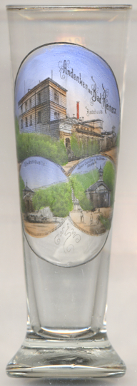
The top picture on glass no. 4670 (which is labeled in German) shows a view of the
 Badehaus
The bottom left picture shows a view of the pavillon of the  Ulrikequelle (Ulrika Spring).
The bottom rightpicture shows a view of the pavillon of the
[https://de.wikipedia.org/wiki/Duszniki-Zdr%C3%B3j, https://en.wikipedia.org/wiki/Duszniki-Zdr%C3%B3j]
 Laue Quelle (Tepid Spring) and
 Molkenanstalt (Whey Institute).
![[scale]](lineal.jpg)