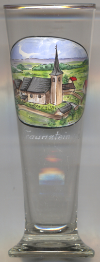

|
| ÖSTERREICH | AUSTRIA |
| Bundesland: Niederösterreich | Lower Austria |
| Bezirk: Zwettl |
 Bad Traunstein is situated at an elevation of 923 m in the Waldviertel region of Austria's federal state of Lower Austria, about
19 km southwest of the district town Zwettl and about 46 km northwest of Sankt Pölten,
the capital of Lower AUstria. The municipality has a population of about 1,000 (2024).
When the parish church was rebuilt, a stone bearing the engraved date 1250 was found; therefore, a church must have existed already back then. The earliest known written document that mentions Trawnstein dates from 1332. In 1371, it already had the status of a parish and was the seat of a local court of law. In 1580 it obtained the status of a market town. At that time it belonged to the domains of Rappottenstein. After the end of manorialism, Traunstein in 1850 became an independent municipality. The neighbouring communities of Moderberg and Spielberg were merged with Traunstein in 1968. In the very early 21st century, Traunstein developed a spa, offering a multitude of different treatment options. Since 20 May 2010, the predicate Bad (spa) is part of the official name of the municipality.
The  parish church Sankt Georg goes back to a church that must have existed already in 1250, since an old stone that
is inscribed with this date has been found in the structure. In 1290, a fief of the Anschau lordship was divided as a church fief between the
Dachsberger family at Rappottenstein castle and the Starhembergers at Albrechtsberg castle. The church obtained the rank of
a parish church in 1909. A new, modern church was built in 1959–1962. The choir of the old church has been preserved as a chapel of the new church.
[https://de.wikipedia.org/wiki/Bad_Traunstein;
https://de.wikipedia.org/wiki/Pfarrkirche_Bad_Traunstein]
![[scale]](lineal.jpg)