
|
| POLSKA | POLAND |
| województwo: Warmińsko-Mazurskie | voivodship: Warmia and Masuria |
| powiat: Piski | county: Pisz |
 Orzysz (former German name: Arys) is situated at an altitude of 252 m at Lake Orzysz in Pisz County of the
Warmia and Masuria voivodship in northeastern Poland. The municipality has a population of about 9,350 (2015).
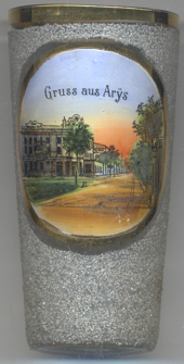
The spelling of the place name Arÿs with ÿ (compare the labeling on the glasses shown here) had been used in former times especially in handwritten texts in place names when y historically was derived from ij, which in older German texts meant a long i ([i:]). The character ÿ was used only very rarely in printed texts.
The location of the town has been inhabited for a long time. In 1895 remains of a settlement dated to
c. 300–1000 AD were discovered near the town on the shores of lake Orzysz. The present settlement was founded
during the East Prussian time by the Grand Master of the Teutonic Order Konrad von Erlichshausen in 1443. The town,
located on a trading route, was granted city rights in 1725 by Friedrich Wilhelm I, King in Prussia. The town
has been occupied frequently: during the Seven Years' War it was held by Russian troops for four years, and troops
where quartered in the town also in 1806–7 and 1812–13. A fire destroyed almost the entire town in 1826.
Again during World War I the town was held by Russian troops for twenty days and almost completely destroyed.
During the East Prussian plebiscite 1920, not a single vote was cast for Poland in the town. The town's population
increased by refugees from parts of West Prussia that had been annexed to Poland. The foundation of a military
training area in 1933 caused a further increase in the population. Towards the end of World War II, the Red Army
occupied the town. In 1945, the southern part of East Prussia became part of Poland and the German-speaking population
was expelled. The former German name of the town, Arys (or Arÿs), was consequently changed to the Polish name, Orzysz.

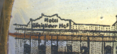
Glass no. 3227 [left] shows a view of
 Hotel
Hotel
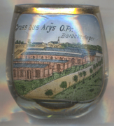
 Glass no. 3506 shows a view of the
 Truppenübungsplatz
Glasses of this collection showing former training areas of the German Empire:
Altengrabow (D),
Arys (Orzysz, PL),
Döberitz (D),
Hagenau (Haguenau, F),
Hammelburg (D),
Hammerstein (Czarne, PL),
Heuberg (Stetten am kalten Markt, D),
Lockstedter Lager (Hohenlockstedt, D),
Münsingen (D),
Munsterlager (Munster, D),
Sennelager (Paderborn, D).
Thorn (Toruń, PL).
Warthelager (Biedrusko, PL).
[https://de.wikipedia.org/wiki/Truppenübungsplätze_(Deutsches_Reich)]
[https://de.wikipedia.org/wiki/Orzysz, https://en.wikipedia.org/wiki/Orzysz;
https://pl.wikipedia.org/wiki/Poligon_Orzysz;
http://fallingrain.com/world/PL/85/Orzysz.html; https://de.wikipedia.org/wiki/Y]
![[scale]](lineal.jpg)