
|
| FRANCE | FRANCE |
| région: Grand Est | |
| département: 51, Marne |
Châlons-en-Champagne is situated at an elevation of 83 m on the river Marne in the région Grand Est of northern France. Until 31 December 2015 Châlons-en-Champagne was the capital of the région Champagne-Ardenne, which then was merged with Alsace and Lorraine into the new region Grand Est (with capital Strasbourg). It is also the chef-lieu (préfecture) of the arrondissement Marne and the sous-préfecture of the arrondissement Châlons-en-Champagne. The municipality has a population of about 45,400 (2005). On 29 December 1997 the name Châlons-en-Champagne replaced the previous name, Châlons-sur-Marne.
 The town existed already in the Gallo-Roman times. At the famous
Battle of Châlons (Battle of the Catalaunian Fields or Battle of Campus Mauriacus) in AD 451, a coalition led by the Roman General Flavius Aetius
and the Visigothic king Theodoric I clashed violently with the Hunnic alliance commanded by King Attila. This battle was the last major military
operation of the Western Roman Empire and has traditionally been considered by many historians to be one of the most important battles of Late Antiquity,
at least in the Latin-speaking world, as it was thought to have halted the Huns advance.
During the Middle Ages the city was administered by the bishops of Châlons. Numerous churches date from that period. On the other hand,
the bishops' rule also limited the activities of the middle classes so that much until today agriculture remained one of the most important economic factors
of the area.
During the Gallo-Roman period the name of the town had been Durocatalaunum or Catalaunum. During the Middle ages this name changed to Chaalons en Champaigne and, after the invention of the accent circonflexe, to Châlons en Champagne. Gradually, under the influence of geographers and the salons of Paris, the toponym sur-Marne became used instead of en-Champagne. Contrary to a popular belief it was not the French Revolution that formally made a decision in favour of the suffix 'sur-Marne'. Both versions of the name were equally used throughout the 18th and 19th century. Nevertheless, the toponym referring to the geographic location on the river Marne finally became the official name of the city. In the 1980's a strong movement formed to return to the historical name. A first decision to do so was made in 1995, but was overturned for formal reasons in April 1997 by the Conseil d'État. On 29 December 1997 the historic name Châlons-en-Champagne finally became the official name of the city again.
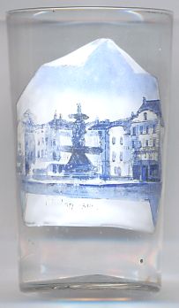
The picture on glass no. 2401 shows a view of
 Place
Place
The  monummental
![[scale]](lineal.jpg)