
|
|
| FRANCE | FRANCE |
| région: Grand Est | |
| département: 67, Bas-Rhin |
map →

Strasbourg is situated at an elevation of 143 m on the river Ill which at this place branches out into several river branches flowing into the Rhine river. Until 31 December 2015 Strasbourg was the capital of the région Alsace, which on 1 January 2016 was merged with Lorraine and Champagne-Ardenne into the new région Grand Est, of which; Strasbourg is the capital. Strasbourg is also the préfecture of the département Bas-Rhin and seat of the administration of the arrondissement Strasbourg. The city has a population of about 290,600 (2020).
Strasbourg was founded by the Romans as Argentoratum after 12 BC next to a Gallic settlement. At first it served as a military outpost in the province Germania Superior. The town became the seat of a bishop already in the 4th century. In the 5th century Strasbourg was conquered by Alemanni, Huns and Franks. The Oaths of Strasbourg of 842 are a remarkable document. With this document Charles II ('the Bald'), ruler of the western Frankish Kingdom, and Ludwig the German, ruler of the eastern Kingdom, confirm their union against their elder brother Lothar I in the struggle for the regnancy in the Frankish Kingdom. The Latin text has come down to us only in a copy of the 10th/11th century. The oaths by the two brothers, are written in their respective languages, Old French and Old High German. It is the oldest known document in French language. During the Middle Ages Strasbourg became a wealthy trading town which in 1262 obtained the status of a Free Imperial City. During the Reformation, the town became Lutheran. At the 1529 Diet of Augsburg, Strasbourg, however, did not join the Confession Augustana but together with Memmingen, Konstanz and Lindau avowed to a confession (subsequently known as Tetrapolitana) drawn up by the reformer Martin Bucer. In 1648 the King of France, Louis XIV, became Imperial reeve of Strasbourg. After the occupation by French troops in 1681 the town finally became part of France in 1697.
 During the industrialisation of the 19th century the town grew rapidly and tripled in size. After the French-German war
of 1870/1871 Strasbourg (German: Straßburg) was declared the capital of the Imperial Territory Alsace-Lorraine
(Reichsland Elsaß-Lothringen). Like Metz and Cologne, Strasbourg was
fortified to become one of the most important fortress towns at the western border of the German Empire.
After World War I Strasbourg was returned to France in 1919 according to the Treaty of Paris
(Versailles) without a referendum. Immediately after the outbreak of World War II the town was evacuated completely.
A few months later, in June 1940, German forces entered the Strasbourg and the town remained occupied until 1944.
In the decades after World War II Strasbourg became a symbol for the reconciliation between France and Germany.
Since 1957 Strasbourg is the seat of the European Parliament. Strasbourg is also the seat of the Council of Europe,
the European Court of Human Rights, and the Eurocorps.
During the industrialisation of the 19th century the town grew rapidly and tripled in size. After the French-German war
of 1870/1871 Strasbourg (German: Straßburg) was declared the capital of the Imperial Territory Alsace-Lorraine
(Reichsland Elsaß-Lothringen). Like Metz and Cologne, Strasbourg was
fortified to become one of the most important fortress towns at the western border of the German Empire.
After World War I Strasbourg was returned to France in 1919 according to the Treaty of Paris
(Versailles) without a referendum. Immediately after the outbreak of World War II the town was evacuated completely.
A few months later, in June 1940, German forces entered the Strasbourg and the town remained occupied until 1944.
In the decades after World War II Strasbourg became a symbol for the reconciliation between France and Germany.
Since 1957 Strasbourg is the seat of the European Parliament. Strasbourg is also the seat of the Council of Europe,
the European Court of Human Rights, and the Eurocorps.
The Grand Île (Big Island), surrounded by two arms of the river Ill, the historic centre of Strasbourg, was listed as a UNESCO World Cultural Heritage site in 1988 (see also list of other UNESCO heritage sites).
 The
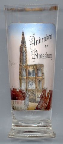
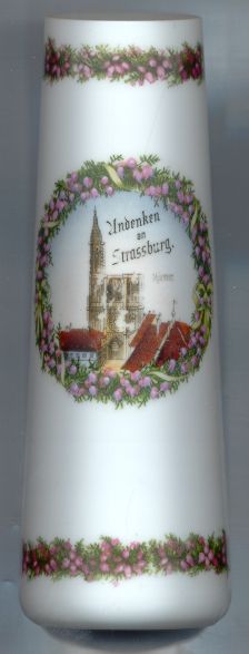
The  cathedral Notre-Dame de Strasbourg [left, no. 3932: top picture, and right, no. 1284]
is one of the most important examples of cathedral architectural design in Europe. The first plans to build the church date
back to 1015 AD and it took six centuries to complete the church. The famous west front, decorated with thousands of
figuers, is a masterpiece of the Gothic period. The north tower, completed in 1439, was the world's highest building
(143 m high) until it was surpassed in height in 1874 by the church Sankt Nikolai in Hamburg
(147 m). In 1892 the cathedral received the papal title Basilica minor.
cathedral Notre-Dame de Strasbourg [left, no. 3932: top picture, and right, no. 1284]
is one of the most important examples of cathedral architectural design in Europe. The first plans to build the church date
back to 1015 AD and it took six centuries to complete the church. The famous west front, decorated with thousands of
figuers, is a masterpiece of the Gothic period. The north tower, completed in 1439, was the world's highest building
(143 m high) until it was surpassed in height in 1874 by the church Sankt Nikolai in Hamburg
(147 m). In 1892 the cathedral received the papal title Basilica minor.
(See also list of other basilicae minores depicted on glasses of this collection.)
The Rhine bridge between Strasbourg and Kehl [left,
no. 3932: bottom left picture] was built in 1858–1886 as the first permanent bridge across the Upper
Rhine. The structure comprised a twin track bridge 253 metres long, with a central truss section of 177 metres.
On each side of the bridge there was a turntable with 26 metres of usable diameter. Work began in 1858. In order to sink the piles into the Rhine mud it was necessary to construct protective
caissons extending 18 metres below the river level. Following the Franco-Prussian War (1870/1871) the frontier moved:
between 1871 and 1919 both ends of the bridge were located in and wholly owned by Germany, but in 1919 it was stipulated
under the terms of the Treaty of Versailles that the bridge would be wholly owned by France. This was consistent with France's military occupation, under the terms of the treaty,
of the formerly German Rhineland: the occupation continued in various forms until 1930. By this time a project had reached
the planning stage to replace the bridge which by now was more than 75 years old, but no such replacement would be built
till well after the Second World War. With the outbreak of war in the late summer of 1939, French troops blew up the bridge's
main western support. Until September 1940 the bridge could nevertheless be used as temporary repairs were undertaken.
In November 1944 German troops blew up the bridge's main eastern support, effectively destroying the bridge in its totality.
A provisional single-track bridge was constructed in 1945, and in 1954–1956 a permanent single-track bridge was
constructed (a second single-track bridge had originally been plannned but never was built). A new, high-speed twin-track
bridge was constructed in 2008–2010.
[https://en.wikipedia.org/wiki/Rhine_Bridge,_Kehl]
Storks[left, no. 3932: bottom right picture] are the popular symbol
animal of Alsace and Strasbourg alwas was known for its many straw nests. However, by the 1970s, only 9 breeding pairs were
left in the area due to the environmental changes causd by the industrialisation. Starting in 1974, an initiative to save
the Alsacian storks began to keep the birds in aviaries for a period of 3 years to discourage them from migrating. The
initiative was so successful that today the birds again can be seen everywhere.
[https://www.suedkurier.de/ueberregional/panorama/Verstopfte-Schornsteine-und-ueberall-Vogelkot-Entwickelt-sich-der-Storch-von-der-bedrohten-Spezies-zur-Plage;art409965,9744832]
The Place Kléber [left] marks the centre of Strasbourg.
Its original name was Barfüßerplatz for the Franciscan monastery which was located here.
In the 17th century the name changed to Waffenplatz ('arms square'). In 1840 the square was finally renamed
for the French general Jean-Baptiste Kléber. Kléber died in 1800. In 1838, his coffin was moved to a
vault in the centre of the square. Above his grave, a monument to him was erected which was unveiled in 1840.
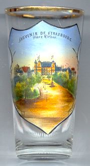
The building depicted in the background of glass no. 1149 [near left] is the
Grand-Hotel
![[scale]](lineal.jpg)