
|
| POLSKA | POLAND |
| województwo: Podkarpackie | voivodship: Subcarpathia |
| miasto na prawach powiatu: Przemyśl | city: Przemyśl |
Przemyśl is situated on the river San in southeastern Poland close to the border to Ukraine, between the Sandomierska lowlands and the foothills of the Carpathian mountains.
The earliest traces of humans inhabiting the area date back some 30–40,000 years. During the 4th century the place seemed to have been a significant administrative and military centre of the Roman empire. The first mention of Przemyśl is found in a document of AD 981 connected to the rivalry between the rulers of Poland, Ruthenia and Hungary. At the turn of the 12th century, Przemyśl was the capital of a Ruthenian duchy, after the mid-14th century it belonged to Poland. The civic rights of the town were confirmed in 1389. From the 17th and 18th century on the dominating ethnic groups were Poles, Ruthenians and Jews (who had first been mentioned here already in 1031). Throughout the centuries, Przemyśl thrived as a trading town at the crossroads of routes connecting the Baltic Sea in the North with Hungary in the South, Kraków in the West and L'viv in the East. After the 1st Partition of Poland in 1772 Przemyśl became part of Austria. Because of its location close to the border to the Russian Empire the Austrians built a system of fortifications which made Przemyśl one of the largest fortresses in Europe.
 After World War I Przemyśl became part of Poland again. Between 1939 and 1941 the river San marked the border between Germany and the Soviet Union.
During the Nazi era practically all the Jews were deported to concentration camps. After the capture of the town by the Red Army the new Polish
authorities resettled the Ukrainina population.
The new borders drawn after the end of World War II deprived Przemyśl of its natural economic base
but the elevation of Przemyśl to the rank of a provincial capital had a beneficial effect on the city.
For centuries Roman Catholic and Greek Catholic bishops had their residences in Przemyśl. During the democratization process the
Catholic diocese of Byzantine-Ukrainian denomination (formerly Greek Catholic), which had been dissolved by the communists and whose
jurisdiction streches over all of Poland, was reestablished in 1991. The territorial
reform of the Roman Catholic dioceses in 1992 resulted in the establishment of the Przemyśl archdiocese.
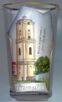
The Baroque  Clock Tower (Wieża Zegarowa) [left] (71 m high) was built in 1775–1777.
Today it houses the Przemyśl museum of bells and pipes.
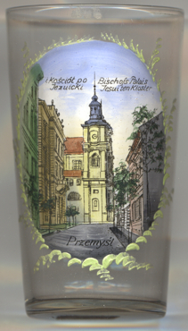
 Glass no. 3676 [near left] shows a view of the
 Ukrainian
[https://en.wikipedia.org/wiki/Cathedral_of_St._John_the_Baptist,_Przemyśl]
The labeling of the picture is in both Polish (i kościół po Jezuicki, 'former Jesuit church') and,
not quite consistent, in German (Bischofs-Palais, Jesuitenkloster, 'episcopal palace, Jesuite monastery').
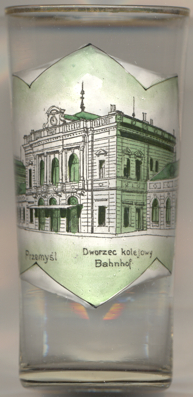
 Glass no. 3677 [near left] shows a view of
 Przemyśl
[https://pl.wikipedia.org/wiki/Przemyśl_Główny]
The labeling of this glass again is in both Polish (Dworzec kolejowy) and in German (Bahnhof),
i.e. 'railway station'.
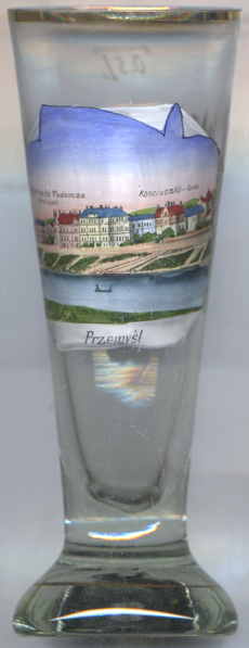
 Glass no. 4609 [near left] shows a view of
 Wybrzeże
![[scale]](lineal.jpg)