
|
|
| ČESKÁ REPUBLIKA | CZECH REPUBLIC |
| Jihočeský kraj | South Bohemia (České Budějovice) region |
| Okres: Tábor |
map →

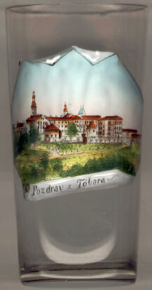
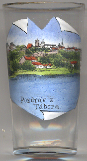
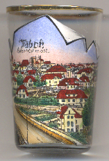
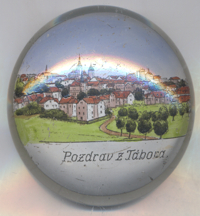
 Tábor is situated at an elevation of 450 m on on a steep hill above the river Lužnice (Luschnitz, Lainsitz) in South Bohemia, about
51 km north-northeast of the capital of the region Southern Bohemia, České Budějovice.
The town is the administrative centre of the eponymous district (okres); the municipality has a population of about 5,100 (2023).
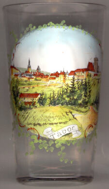
Tábor is situated at an elevation of 450 m on on a steep hill above the river Lužnice (Luschnitz, Lainsitz) in South Bohemia, about
51 km north-northeast of the capital of the region Southern Bohemia, České Budějovice.
The town is the administrative centre of the eponymous district (okres); the municipality has a population of about 5,100 (2023).
The forerunner of Tábor was a settlement called Hradiště, founded in the 13th century. Tábor itself was founded by the Hussites in 1420 on a hill above the river, and originally received the name Hradištì of Mount Tábor. After the defeat of the Táborites in the Battle of Lipany in 1434, the community signed a contract with Emperor Sigismund, who granted Tábor the privileges of a Royal Town in the following year. The town's fortifications, going back to the Hussites, once were among the strongest of the country. The barbican is said to be an invention of the Hussites. Tábor also is famous for the network of passages and cellars under the town which served as a refuge when the town was attacked or during the frequent fires. After the Battle of the White Mountain (Bílá Hora, today part of Prague) (1620), Tábor was invaded several times and became a poor town, so that the town preserved most of its many Renaissance houses and façades.
This page is about Tábor in southern Bohemia. There is also a page for hora Tábor
(Tábor hill) in northern Bohemia.
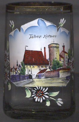

 Kotnov castle [near left, no. 3960]
is located on a promontory in the southwestern part of the historic town. The best preerved part of the castle ist the
round battery tower. The castle was founded by King Přemysl Otakar II to protect the town of
Hradiště; however, the earliest known mention in a written document only from 1370, when the town no longer
existed. After the foundation of Tábor, the castle was incorporated into the town's fortifications. The
fortificatins were improved in the early 15th century. However, after a large fire in 1532, the castle was used
as a brewery, and subsequently parts of the former castle were demolished.
Kotnov castle [near left, no. 3960]
is located on a promontory in the southwestern part of the historic town. The best preerved part of the castle ist the
round battery tower. The castle was founded by King Přemysl Otakar II to protect the town of
Hradiště; however, the earliest known mention in a written document only from 1370, when the town no longer
existed. After the foundation of Tábor, the castle was incorporated into the town's fortifications. The
fortificatins were improved in the early 15th century. However, after a large fire in 1532, the castle was used
as a brewery, and subsequently parts of the former castle were demolished.
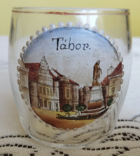
The Žižka monument was created in in 1884 by the sculptor Josef Strachovský. It replaced
an earlier bronze statue, which had been created by the then beginning (and later famous) sculptor Josef Václav Myslbek but had to be
removed because of a defect in the material.
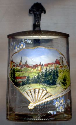
The Švehl bridge (Švehlův most) [left, no. 4754: foreground]
spans the river Lužnice on the southwestern edge of the town. By the end of the 1920s, the road from Tábor to
the west had become unbearable due to the increase in road traffic, especially in winter. Construction of the modern arched
reinforced concrete bridge started in 1933/1934 and was completed in 1935. The first class bridge with a load capacity of
22 tons is 167 metres long and the arch is 25 metres above the river level. The road in the direction from
Tábor rises at a gradient of 5%, so the difference in height between the two bridgeheads is approximately 8.5 metres.
The bridge is named for Antonín Švehl, former Prime Minister of Czechoslovakia. During the period of the communist
regime, it was renamed Sokolovo Bridge.
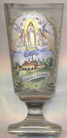
The pilgrimage site and monastery of Klokoty with the Church of the Assumption of Our Lady
[left, no. 5107] is located in the southern outskirts of the city of Tábor. In the 13th century,
a fortress stood on this hill. A small pilgrimage church was built here in the 14th century. The first mention of it dates
to 1361. However, in 1421, it was demolished the followers of Jan Žižka. In 1679, the construction of the Baroque
pilgrimage site began, but it took until 1743 to be completed. The center of the complex is the church of the Assumption of the
Virgin Mary from 1708. Later, a crypt and chapel of St. Wenceslas and St. Joseph were built under the church.
In 2018 the pilgrimage site with the church of the Virgin Mary was declared a national cultural monument.
[https://de.wikipedia.org/wiki/Luha%C4%8Dovice, https://en.wikipedia.org/wiki/Luha%C4%8Dovice;
https://cs.wikipedia.org/wiki/%C5%A0vehl%C5%AFv_most;
https://www.visittabor.eu/jan-zizka-von-trocnov-denkmal;
https://cs.wikipedia.org/wiki/Kl%C3%A1%C5%A1ter_Klokoty]
![[scale]](lineal.jpg)