
|
|
| UNITED STATES OF AMERICA | |
| IOWA | |
| Fremont County & Page County |
map →

 Shenandoah, IA is situated at an elevation of 306 m along Fourmile Creek near its confluence with the East Nishnabotna River,
on the border of Fremont and Page Counties in southwestern Iowa. The municipality has a population of about 4,900 (2020).
Shenandoah, IA is situated at an elevation of 306 m along Fourmile Creek near its confluence with the East Nishnabotna River,
on the border of Fremont and Page Counties in southwestern Iowa. The municipality has a population of about 4,900 (2020).
Shenandoah, originally known as Fair Oaks, was platted in 1870, shortly after the arrival of the Chicago, Burlington and Quincy Railroad into the neighborhood. Its name is derived from the local valley's resemblance to the Shenandoah Valley, in Virginia.
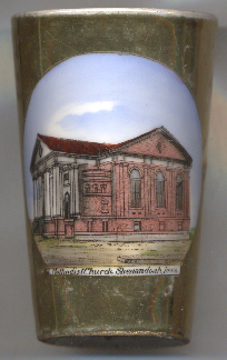
Tumbler no. B063 shows a view of the
 Methodist Church
[https://en.wikipedia.org/wiki/Shenandoah,_Iowa;
https://republicanherald4.rssing.com/chan-15221936/article14805.html?nocache=0]
![[scale]](lineal.jpg)