
|
| UNITED STATES OF AMERICA | |
| PENNSYLVANIA | |
| Allegheny County |
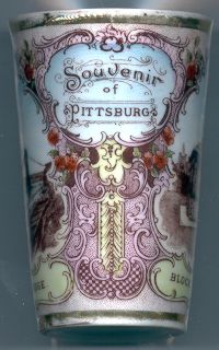
 Pittsburgh, the seat of Allegheny County in southeast Pennsylvania, is situated at the confluence of the Allegheny and Monongahela rivers,
which there form the Ohio river. Pittsburgh has a population (2000) of 334,500.
In the late 17th century the site was occupied by the Native American town of Shannopin, a fur-trading post. In the middle of the 18th century the French completed Fort Duquesne which later fell to the English and was renamed Fort Pitt. The village near the fort was founded in 1760 and prospered with the opening of the Northwest Territory by the adoption by Congress of the Northwest Ordinance in 1787. In 1816 Pittsburgh was incorporated as a city. In the late 19th century, Pittsburg was a center of steel industry and was nicknamed "Steel City" or "Smokey City". Industrial production decreased in the 1970's and Pittsburgh developed into an attractive city.
In 1890 the spelling of the name Pittsburgh was officially changed to Pittsburg when the United States Board on Geographic Names decided that the 'h' be dropped from all place names ending in '-burgh'. The name Pittsburgh nevertheless remained popular and even city ordinances and minutes retained the historic spelling. After protests from citizens the United States Board on Geographic Names reversed its decision and restored the 'h' to Pittsburgh in 1911. There are 18 other places in the United States named Pittsburg (without 'h') and even one other Pittsburgh (with 'h'), a tiny place in North Dakota. The inscription on tumbler no.B013 [left] uses the spelling "Pittsburg".
Stephen Foster (1826–1864), the American song writer and composer, was born in Pittsburgh.

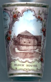
The  Block House [right] in Point State Park is preserved as the only part of the once great Fort Pitt,
which protected the Ohio valley for the British Crown. The fort was begun by a groop of Virginians in 1754 and was completed in the same year by the
French who had driven away the Virginians. The fort was named Fort Duquesne in honour of Ange Duquesne-Menneville, Marquis de Duquesne,
the governor of New France. In 1758 the French abandoned it and the advancing British troops burnt the fort. The fort was rebuilt by the English who
renamed it Fort Pitt in honour of William Pitt, 1st Earl of Chatham, the English Prime Minister (Pittsfield in Massachusetts
also was named for him).
The blockhuose is a five-sided two-story strong point constructed in 1764 outside the palisaded walls of the fort towards the Point (the confluence of the
Allegheny and Monongahely rivers. It is the oldest stone building in original condition in Allegheny County.
Because the blockhouse stood by itself it escaped the wreckers' hammers when the fort was dismantled in 1772, only thirteen years after it had been built.
By the early 1900's the area had degenerated to slum conditions. Plans to develop the area were hindered by the blockhouse, which was a property of
the DAR (Daughters of the American Revolution). A long and fierce court battle was finally resolved in favour of the blockhouse.

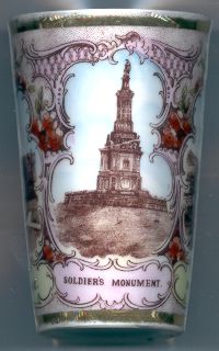
The  Soldier's Monument [left] was created in 1871 by the sculptor
P. C. Reniers and the architect Louis Morganroth as a memorial to the Civil War. Its original location was on the north side of Monument Hill.
In 1931 it was moved to West Park. At the same occasion it was redesigned to the aesthetic tast of the 1930's
and only the original spire with the figure of Fame on top have remained from the original design.

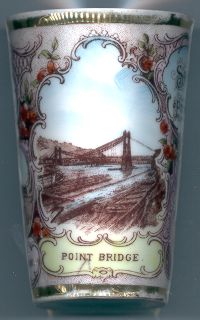
The  Point Bridge [right] across the mouth of Monongahela river was built in 1875–1877.
The suspension bridge had a length of 1,234 ft (376 m) from back to back of the anchorages with one middle span of 800 ft
(244 m) and one independent-trussed side span of 145 ft (44 m) at each shore. The roadway rose from both shores toward the
center of the channel with grades not exceeding 3 in 100 – the highest point of the roadway being 83 ft (25 m) above low water.
The saddles upon which the chains rest on top of the wrought-iron towers were 180 ft (55 m) above low water. The City of Pittsburgh
acquired the bridge in 1896, already in a deteriorated state. In 1903 the bridge was closed to heavy traffic. Although reconstruction works in 1904
could repair some of the damages the bridge had to be closed for heavy traffic again in 1924.
The Second Point Bridge, a steel cantilever construction, was built in in 1925–1927 in parallel to the old bridge. The new bridge was closed
for traffic in 1959 when the Fort Pitt Bridge across the Monongahela was opened. The Point Bridge was finally dismantled in 1970.
![[scale]](lineal.jpg)