

|
| DEUTSCHLAND | GERMANY |
| Bundesland: Nordrhein-Westfalen | North Rhine-Westphalia |
| Regierungsbezirk: Arnsberg | |
| Stadt: Dortmund |
 Dortmund is situated at an elevation of 50 m at the northern edge of the Ruhrgebiet industrial region between the rivers
Ruhr and Lenne and the Datteln-Hamm canal, and at the end of the Ems–Dortmund canal.
Dortmund was first mentioned as Throtmani in a document of between AD 880 and 890.
In the 13th century, Dortmund was one of the richest and most important towns of the Hanse federation of trading towns.
The town was unsuccessfully besieged by an army of 1,200 men led by 45 princes in 1388–1390 (the 'Dortmunder Fehde').
During the Thirty Years' War, Dortmund was conquered by the infamous General Pappenheim in 1632.
Until 1803 the town had the status of a free imperial town. Until 1806 it was ruled by Nassau-Orange. In 1808 it came under French rule
and became part of the Grand Duchy of Berg. Dortmund participated in the war against Napoleon at the side of Prussia which ended the
French occupation in 1813. The industrial development of the town was boosted by the opening in 1847 of the railway line from Cologne
via Dortmund to Minden. In order to establish a cheaper means of transport to the North sea harbours, the Dortmund–Ems canal
was built between 1892 and 1899. At that time, Dortmund was the largest and most important industrial town of the Ruhr region. After World War I,
Dortmund was occupied by France between 1923 and 1924. During World War II, 95% of the historical parts of the town and 59% of the residential quarters
were destroyed. Today, Dortmund is a thriving city with 580,000 inhabitants.
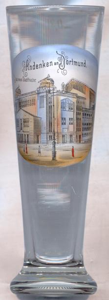
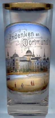
The  Stadttheater (old municipal theatre) [left, no. 957] was built in 1903–1904 by the architect
Martin Dülfer. In its place, the new Opera House was built in 1966.
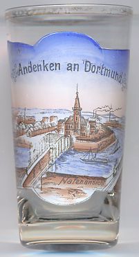
Constructions on the  Dortmund Port [near left, no. 2340], which terminates the Dortmund–Ems Canal
connecting Dortmund to the North Sea, started in 1895. It was opened 1899 by Emperor Wilhelm II. At the beginning of the 20th century the port was
mainly used for the import and export of wheat, coal and ore. The port was expanded in the 1920s and 1930s by adding new docks as well as on the
administrative infrastructure (Dortmunder Hafenamt). Today Dortmund Port is the biggest European canal port with 10 docks and a pier-length of
11 km.
[http://en.wikipedia.org/wiki/Dortmund_Port]
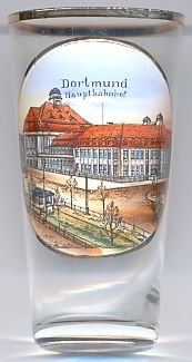
The  Hauptbahnhof is the mail railway station for the city of Dortmund.
The station's origins lie in a joint station of the Köln-Mindener Eisenbahn and Bergisch-Märkische Eisenbahn which was built north of the city
centre in 1847. That station was replaced by a new station, erected in 1910 at the current site; this building is depicted on glass no. 2341
[near left]. It featured raised embankments to allow a better flow of traffic. At the time of its opening, it was one of the largest stations
in Germany. It was, however, destroyed in an Allied air raid on October 6, 1944. The main station hall was rebuilt in 1952 in a contemporary style.
Its stained glass windows feature then-common professions of Dortmund. Dortmund Hauptbahnhof is the third largest long distance traffic junction in Germany
and even one of the most important train stations in Europe.
[http://en.wikipedia.org/wiki/Dortmund_Hauptbahnhof]
 Hörde is a district in the borough of the same name in the south of the city of Dortmund. The formerly independent city in the county of Mark
and district seat of the district of Hörde was incorporated into Dortmund in 1928. From 1911 to 1928 Hörde formed its own urban district.
Hörde (Huryde, Huride) was first mentioned in a written document in 1198. In the 12th century, Hörde castle was built by the
lords of Hörde. The count von der Mark founded the Clarenberg monastery in 1339 and in the following year granted Hörde city rights. The counts
of Mark also granted these rights to Herdecke, Witten, Bochum, Castrop, Lünen, Unna and Schwerte,
with the intention of surrounding the 'enemy' city of Dortmund with his own towns. After 1753, Hörde was one of the four district towns in the
county of Mark. After the incorporation of the county into Prussia, the town in 1817 became part of the district Dortmund, from which the district
Hörde was separated in 1887. Between 1911 and 1928, the city had the status of an independent city district. On 1 April 1928, Hörde and
several other municipalities were incorporated int the city of Dortmund.
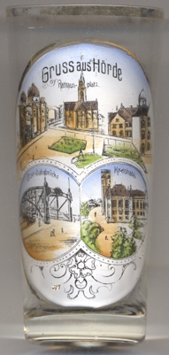
The Protestant  Lutherkirche of Hörde [left, no. 4195: top picture: centre]
was built in 1886–1889 by the architect Peter Zindel. Following severe damages during World War II, the church was renovated and the interior
was completely redesigned.
The former  Synagoge of Hörde [left, no. 4195: top picture: left]
stood at the southern side of the former Rathausplatz (town hall square; today Friedrich-Ebert-Platz).
A private prayer room was already mentioned in 1777, a first synagoge was built in 1818. When this had become to small for the local jewish community,
the new synagogue was built in 1898/1899 and inaugurated in 1900. The building was extensively renovated in 1929. However, it was destroyed by fire
during the Kristallnach pogrom on 9/10 November 1938. A few months later, the ruins were removed.
The old  Hörder Brücke [left, no. 4195: bottom left picture]
spanned the tracks of the railroads Dortmund–Soest and Dortmund–Schwerdte. The iron truss bridge was built in
1903 because the volume of traffic at the level crossing had become too high and the barriers blocked traffic up to 167 times a day on the busy
railway line. The structure was approved for all road traffic including trams. In 1959, after a severe accident on the bridge, the bridge was declared
'no longer viable'. A modern concrete bridge was built to the east of the old bridge in the early 1960s, and the old steel bridge was then dismantled
in 1964/65.
The bottom right picture on glass no. 4195 shows a view of the old
 Kreishaus
[https://de.wikipedia.org/wiki/H%C3%B6rde; https://de.wikipedia.org/wiki/Liste_von_Sakralbauten_in_Dortmund; https://de.wikipedia.org/wiki/Synagoge_(H%C3%B6rde); https://de.wikipedia.org/wiki/H%C3%B6rder_Br%C3%BCcke; https://nat.museum-digital.de/object/1208078]
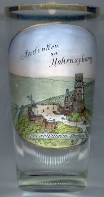
The  Hohensyburg [right] is an elevated plateau (245 m)
in the south of the city of Dortmund near the river Ruhr.
Syburg was first mentioned in AD 775 after the Saxon fort Sigiburg
had been conquered by Charlemagne. Syburg was an independent community in the domain Westhofen which until
1806 was in possession of the Counts von der Mark. In 1806 it became part of Prussia.
In 1929 it became part of Dortmund, at first as part of the borough Wellinghofen,
since 1975 it is part of the borough Hörde.
 The
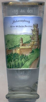
The  Kaiser-Wilhelm-Denkmal [right, no. 1888, and left, no. 2005] on the Hohensyburg
was built in 1893–1903 in memory of the first German Emperor, Wilhelm I, who had died in 1888.
Although Dortmund in 1889 lost the competition for the construction of the central monument for the province of
Westfalia to Porta Westfalica, a regional committee soon proposed plans for another
monument for the former County of Mark. The designs were drawn by the architect Hubert Stier. The
equestrian monument of Emperor Wilhelm and the statues of Otto von Bismarck, Helmuth von Moltke,
Crown Prince Friedrich Wilhelm (Emperor Friedrich III) and Prince Friedrich Karl (nephew of Wilhelm I),
were designed and executed by Adolf Donndorf and his son Karl. The central tower has a total height
of 34 m. The monument was unveiled on the 30th of June 1902 in the presence of Emperor Wilhelm's
great-grandson, Crown Prince Wilhelm, son of the reigning German emperor, Wilhelm II.
During extensive reconstructions in 1935/36 the statues of Friedrich Wilhelm and Friedrich Karl
were removed, and the two other statues were repositioned.
Glass no. 2005 [left] is marked “Andenken an den Kaiserbesuch 10. Aug. 1909”. It was sold as a souvenir on the occasion of the visit of Emperor Wilhelm II, on the occasion of the celebrations of 300th anniversary of the affiliation of the Counties Mark and Ravensburg (Bielefeld) to Brandenburg-Preußen.
Several glasses of this collection show other monuments for Wilhelm I.
The  Fredenbaum [left, no. 2079]
is the oldest and second-largest (ca. 65 ha) municipal park in Dortmund.
Until about 1835 the forest “Westerholz” marked the northern city border between Dortmund and the county of Mark.
A border station finally gave the forest its modern name, “Fredenbaum”, a contraction of the words “Frede&rdqu; (Freiheit, freedom) and “Baum” (Schlagbaum, toll bar).
In the late 19th century, the forest became a popular resort place and amusement venue. The building depicted on glass no. 2078 [right] is the
 Fredenbaumsaal
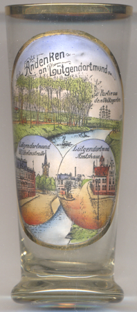
Lütgendortmund is the statistical district 73, located in the western part of the city district of the same name of Dortmund. The earliest known written mention referring to this place, albeit under a different name (Throtmannia minor), is found in an urbarium of the abbey of Essen-Werden. In 1254 it was mentioned as Parva Tremonia and in 1290 for the first time as Luttiken-Dortmunde; all of these names mean the same, namely 'Minor Dortmund'. When the coal mine Zeche Zollern I was opened in 1858, the population of Lütgendortmund began to grow rapidly. In 1907, the neighbouring municipality of Dellwig-Holte was incorporated into Lütgendortmund, which itself was incorporated into the city of Dortmund in 1928.
The pictures on glass no. 3126 [left]
show:
[top picture]: A view from the
 municipal
[bottom left]:
 Limbecker Straße: together with the market square it forms the centre of the
Lütgendortmund. Before the town's incorporation into Dortmund, the street was named Wilhelmstraße
(as labeled on the glass). In the background: the Protestant
  church of
[bottom right]:
The Lütgendortmund  Amtshaus was originally founded in 1886 when the 'Amt' (municipality)
was founded out of the villages of Lütgendortmund, Bövinghausen, Dellwig, Kirchlinde, Kley, Oespel and Westrich.
This original building soon was too small and in 1895 a new town hall was opened. After the incorporation of Lütgendortmund
into Dortmund, the building remained the seat of the new city district admministration. The building was thoroughly renovated
in 2016.
[https://de.wikipedia.org/wiki/Lütgendortmund; https://de.wikipedia.org/wiki/Volksgarten_Lütgendortmund;
http://www.ev-kirche-dortmund.de/kirche-und-stadt/fundraising/stiftung-denkmalswerte-kirchen/kirchen/kirchen-in-dortmund/11-bartholomaeuskirche-luetgendortmund/;
https://bochumerzeitung.com/2016/10/05/stadt-dortmund-infosbeliebter-ortsmittelpunkt-das-amtshaus-luetgendortmund-denkmal-des-monats-oktober-2016/]
![[scale]](lineal.jpg)