
|
| ÖSTERREICH | AUSTRIA |
| Bundesland: Kärnten | Carinthia |
| Bezirk: Sankt Veit an der Glan |
 Sankt Veit an der Glan is situated at an elevation of 482 m in the valley of the river Glan.
The municipality has a population of about 12,700 (2011).
The oldest written document mentioning ville Sancti Viti dates from 1137 and refers to the ownership of the monastery of Gurk. In 1137 the bishopric of Bamberg repurchased the village. However, by 1176 the duke of Carinthia had become in possession of Sankt Veit and the place soon became the centre of Carinthia. In 1199 Sankt Veit was mentioned as 'forum', i.e. a market town. In the first half of the 13th century, the place was fortified. Between 1205 and 1725 Sankt Veit was the seat of the ducal mint. The oldest known coin with a German inscription was minted here in 1220. In 1224 Sankt Veit was chartered as a town. However, Sankt Veit lost its position as a residence town when Carinthia in 1335 came in possession of the Habsburgs. Nevertheless, it remained the capital of the duchy of Carinthia unti 1518 (since then the capital is Klagenfurt am Wörthersee). The commercial privileges, which the town enjoyed since the Middle Ages, were abolished in 1783 which caused an economical downfall. The decline was only reversed after the Rudolfsbahn (Crown Prince Rudolf Railroad from Sankt Valentin via Steyr, Selzthal, Sankt Michael in Obersteiermark, Sankt Veit an der Glan, Feldkirchen in Kärnten and Villach to Tarvisio) had been built in 1868–1873.
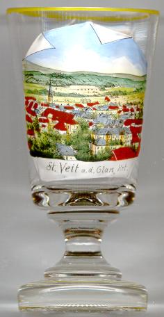
The Catholic  parish church of St. Vitus and the Holy Trinity [left, no. 817: background left]
was already mentioned in 1131. The basic parts of the church go back to the late Romanesque period, most parts of the structure date from the late Gothic period.
Its outer appearance was shaped in the Baroque period when it was rebuilt after a large fire had damaged the church in 1829.
The patrocinium of the Holy Trinity was added to the original one of St. Vitus in the 18th century.


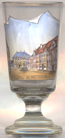
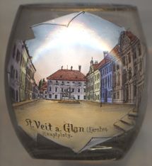
The  Hauptplatz (Main Square) [near left, no. 2715, and right, no. 4737]
marks the centre of the historic old town. The buildings encircling the square date back to the Middle Ages whie their façade
were created in 17th, 18th and 19th century.
The  Town Hall [near left, no. 2715: right (barely visible), and right, no. 4737: right (barely visible)]
goes back to the 15th century. Of this building the main portal with its characteristic keal arch and a metal plate dating it to 1468 have remained.
The Renaissance arcades of the courtyard were created around 1540.
The façade of the town hall was redecorated in Baroque style in 1754.
The grand hall on the first floor stl features the original Gothic vaulting with the Baroque stucco work of the 18th century.
The building depicted in the centre background was built as a representative residential building after 1790. It is used today as the seat of the
district administration
( Bezirkshauptmannschaft
The  Vogelweide Fountain [near left, no. 2715: centre left]
in the southwest part of the square is one of two fountains adorning the square.
The fountain was created in 1676 and commemorates the famous minstrel Walther von der Vogelweide who had stayed in Sankt Veit in 1214.
The statue of Walther von der Vogelweide on top of the fountain was replaced by a copy in 1960.

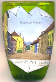
Glass o. 3020 [left] shows a view of
 Unterer
Another glass in this collection is from Sankt Veit an der Gölsen, Lower Austria.
[https://de.wikipedia.org/wiki/Sankt_Veit_an_der_Glan,
https://de.wikipedia.org/wiki/Pfarrkirche_Sankt_Veit_an_der_Glan,
http://www.sv.or.at/stveit/stadt/sehenswuerdigkeiten.php]
![[scale]](lineal.jpg)