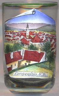

|
| ÖSTERREICH | AUSTRIA |
| Bundesland: Niederösterreich | Lower Austria |
| Bezirk: Krems an der Donau |
 Langenlois is situated at an elevation of 219 m in the lower Kamp valley. It is one of Austria's best-known wine-growing communities.
It was first mentioned in 1082 (as Liubisa) and 1141 (as Liubes). Langenlois obtained the status of a market town in 1310.
Further privileges were granted in 1346, 1411 and 1518.
Since 1925 Langenlois has the status of a town.
 The
The  parish church Sankt Laurentius [centre]
goes back to a church of the Romanesque period; however, most parts of the present church date from the
Gothic period. The tower of the church was heightened and remodeled in Baroque style in 1754–1756.
A renovation in 1959/1960 aimed at restoring the Gothic appearance of the church.
While glass no. 671 [left] is labeled Sommerfrische Langenlois N.Oe.
('summer resort Langenlois Niederösterreich'),
glass
[https://de.wikipedia.org/wiki/Langenlois]
![[scale]](lineal.jpg)