
|
|
| DEUTSCHLAND | GERMANY |
| Bundesland: Niedersachsen | Lower Saxony |
| Landkreis: Ammerland |
map →

Westerstede is situated at an elevation of 10 m in the northwest of Germany's state of Lower Saxony, about 24 km northwest of Oldenburg, about 63 km northwest of Bremen and about 157 km northwest of the Lower Saxon capital, Hannover. Westerstede is the administrative seat of the district Ammerland. The municipality has a population of about 93,900 (2024).
The settlement was first mentioned in 1123 in a document referring to the foundation of the church of St. Peter (see below). In the 15th and 16th centuries, Westerstede and the surrounding villages frequently suffered as a result of the military feuds between the counts of Oldenburg and the East Frisian chieftains over supremacy in North Oldenburg. Luckily, the county of Oldenburg, and consequently Westerstede, were largely spared the hostilities of the Thirty Years' War (1618–1648). The vilage obtained the privileges of a market town in 1785. In 1858 Westerstede became the administrative centre of the district (Amt) of the same name. The modern district (Landkreis) Ammerland was created in 1933 with the inclusion of the municipalities of Rastede and Wiefelstede from the former Amt Oldenburg.
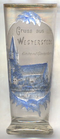
The  Petrikirche (church of Saint Peter) [left, no. 0000] is the largest church and popular
landmark of Westerstede. The oldest, Romanesque, church on this site was built in 1123, but this church was replaced by a new structure one
century later, in 1232. The present chancel was added in the 13th/14th century. The western tower, original only a one-storey construction,
was heightened to its present shape by the addition of two storeys in the second half of the 13th century. Since the 1570s the church
is Protestant. Small parts were added to the church in the 19th century, and major renovation works were carried out in 1955–1956.
Petrikirche (church of Saint Peter) [left, no. 0000] is the largest church and popular
landmark of Westerstede. The oldest, Romanesque, church on this site was built in 1123, but this church was replaced by a new structure one
century later, in 1232. The present chancel was added in the 13th/14th century. The western tower, original only a one-storey construction,
was heightened to its present shape by the addition of two storeys in the second half of the 13th century. Since the 1570s the church
is Protestant. Small parts were added to the church in the 19th century, and major renovation works were carried out in 1955–1956.
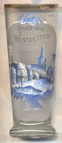
Glass no. 0000 [right] shows a view of Kirchenstraße ('Church Street') leading towards
St. Peter's church.
[https://de.wikipedia.org/wiki/Westerstede;
https://de.wikipedia.org/wiki/Landkreis_Ammerland;
https://de.wikipedia.org/wiki/St.-Petri-Kirche_(Westerstede)]
![[scale]](lineal.jpg)