
|
|
| ČESKÁ REPUBLIKA | CZECH REPUBLIC |
| Středočeský kraj | Central Bohemia region |
| Okres: Kutná Hora |
map →

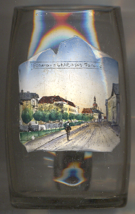 Uhlířské Janovice is situated at an elevation of 423 m on the river Výrovka in Central Bohemia,
about 17 km southwest of the district town Kutná Hora and about 50 km southeast of
Prague. The municipality has a population of about 3,200 (2023) and apart from Uhlířské Janovice
also includes the settlements Bláto, Janovická Lhota, Kochánov, Malejovice, Mitrov, Opatovice II and Silvánka.
Uhlířské Janovice is situated at an elevation of 423 m on the river Výrovka in Central Bohemia,
about 17 km southwest of the district town Kutná Hora and about 50 km southeast of
Prague. The municipality has a population of about 3,200 (2023) and apart from Uhlířské Janovice
also includes the settlements Bláto, Janovická Lhota, Kochánov, Malejovice, Mitrov, Opatovice II and Silvánka.
The oldest known written document that mentions the place dates from 1352. It was named Janovice after Jan of Sternberg (Šternberk) who founded the settlement, probably in 1250. The attribute Uhlířské was added to distinguish it from other places with the same name and refers to the charcoal burners (Czech: uhlíři) that lived here. The town was owned by the Sternberg family until 1750, when it was merged with the Rataje estate.
The  parish church of Saint Aloysius [left, no. 4927: background]
was built in the late Baroque style in 1767–1795.
parish church of Saint Aloysius [left, no. 4927: background]
was built in the late Baroque style in 1767–1795.
[https://de.wikipedia.org/wiki/Uhl%C3%AD%C5%99sk%C3%A9_Janovice, https://en.wikipedia.org/wiki/Uhl%C3%AD%C5%99sk%C3%A9_Janovice]
![[scale]](lineal.jpg)