
|
|
| DEUTSCHLAND | GERMANY |
| Bundesland: Niedersachsen | Lower Saxony |
| Landkreis: Aurich |
map →

Borkum (East Frisian Low German: Börkum, Frisian: Boarkum) is the westernmost and, at just under 31 square kilometres, the largest of the East Frisian Islands (Borkum, Memmert, Juist, Norderney, Baltrum, Langeoog, Spiekeroog and Wangerooge). Parts of the island and the adjacent mudflats belong to the Lower Saxony Wadden Sea National Park. The municipality of Borkum, which covers the entire area of the island, is a state-recognised North Sea spa resort.
 Mentioned as Burchana fabaria (island of beans) by both Strabo and Pliny the Elder, Borkum by the time of
the 8th/9th century was part of a larger island called Bant, which consisted of the present-day
islands of Borkum, Juist, and the western part of Norderney. In 1484, Bant passed to the Earls of East Frisia,
who developed trade, and the island became known as a centre of piracy and whaling. By 1781, violent storms in
the 18th century divided Bant into three islands. As whaling decreased, many inhabitants left. The first
tourists arrived on the island in 1834, and the local economy improved as a tourist resort.
Mentioned as Burchana fabaria (island of beans) by both Strabo and Pliny the Elder, Borkum by the time of
the 8th/9th century was part of a larger island called Bant, which consisted of the present-day
islands of Borkum, Juist, and the western part of Norderney. In 1484, Bant passed to the Earls of East Frisia,
who developed trade, and the island became known as a centre of piracy and whaling. By 1781, violent storms in
the 18th century divided Bant into three islands. As whaling decreased, many inhabitants left. The first
tourists arrived on the island in 1834, and the local economy improved as a tourist resort.
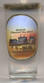
The view depicted on glass no. 4919 [left] is labelled
Borkum. Strand mit den Hotels. ('Borkum. Beach with the hotels.'). The hotels depicted on the glass
are (tentatively) identified as
 Köhlers Hotel Villa
[https://de.wikipedia.org/wiki/Borkum, https://en.wikipedia.org/wiki/Borkum;
https://olde-tieden.de/Abs_Borkum/e4_kaiserstrasse.htm]
![[scale]](lineal.jpg)