
|
|
| DEUTSCHLAND | GERMANY |
| Bundesland: Sachsen-Anhalt | Saxony-Anhalt |
| Landkreis: Jerichower Land |
map →

 Jerichow is situated at an elevation of 37 m on an old branch of the Elbe river in the very north of
the Jerichower Land district, about 28 km northeast of the district town Burg and
about 52 km northeast of Magdeburg, the capital of Germany's state of Saxony-Anhalt.
The municipality has a population of about 6,600 (2024).
Jerichow is situated at an elevation of 37 m on an old branch of the Elbe river in the very north of
the Jerichower Land district, about 28 km northeast of the district town Burg and
about 52 km northeast of Magdeburg, the capital of Germany's state of Saxony-Anhalt.
The municipality has a population of about 6,600 (2024).
The place name is of Slavic origin (‘castle of the brave’) and therefore not biblical. Jerichow was first mentioned in a document at the end of 1144. The occasion was the founding of Jerichow Abbey by Premonstratensian canons from the estates of the count of Stade. Jerichow was granted town rights in 1336. In 1631, during the Thirty Years' War (1618–1648), the town was destroyed and plundered. Since 1680, the town belonged to the Brandenburg-Prussian Duchy of Magdeburg and was located in what was then the Jerichow district, which in 1816 was partitioned into the districts Jerichow I (with the addition of the former district Ziesar; administrative centre Loburg, 1818 Leitzkau, 1850 Loburg, and since 1877 Burg) and Jerichow II (administrative centre Genthin, 1846 Redekin, since 1848 again Genthin). The districts Burg and Genthin (formed after the administrative reform of 1950) were merged in 1994 into the current district Jerichower Land.
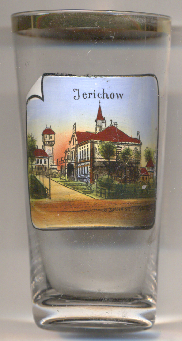
The tower depicted in the background left is the  water tower of the
former Landesheilanstalt (state hospital) Jerichow.
water tower of the
former Landesheilanstalt (state hospital) Jerichow.
[https://de.wikipedia.org/wiki/Jerichow;
https://de.wikipedia.org/wiki/Jerichowscher_Kreis, https://de.wikipedia.org/wiki/Landkreis_Jerichow_I, https://de.wikipedia.org/wiki/Landkreis_Jerichow_II]
![[scale]](lineal.jpg)