
|
|
| DEUTSCHLAND | GERMANY |
| Bundesland: Baden-Württemberg | |
| Regierungsbezirk: Stuttgart | |
| Landkreis: Ostalbkreis |
map →

 Neubronn is situated at an elevation of 508 m in the Ostalb district of Germany's state of
Baden-Württemberg, about 3 km southwest of Abtsgmünd, about 11 km northwest of the
district town Aalen, and about 60 km east-northeast of
Stuttgart. Today, Neubronn is part of the municipality of Abtsgmünd.
Neubronn is situated at an elevation of 508 m in the Ostalb district of Germany's state of
Baden-Württemberg, about 3 km southwest of Abtsgmünd, about 11 km northwest of the
district town Aalen, and about 60 km east-northeast of
Stuttgart. Today, Neubronn is part of the municipality of Abtsgmünd.
Neubronn was first mentioned in 1266 and originally was in possession of the monastery of Ellwangen. In 1385 it was mentioned as Nuwenbrunnen. In 1805 it became part of the Electorate (1806 Kingdom) of Württemberg, where it was allocated to the district Aalen. Between 1806 and 1820 it was part of the municipality of Laubach. In 1971, it was incorporated into the municipality of Abtsgmünd.
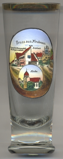
 Neubronn castle [top right] goes back to a medieval castle
that was first mentioned in a document dating from 1376. In 1783, the castle was converted into a two-winged
château, which around 1870 was redesigned in the Neo-Renaissance style.
Neubronn castle [top right] goes back to a medieval castle
that was first mentioned in a document dating from 1376. In 1783, the castle was converted into a two-winged
château, which around 1870 was redesigned in the Neo-Renaissance style.
The Protestant church [bottom picture] of Neubronn was built
around 1600 in place of an older church that had been dedicated to St. Ambrosius. The church was renovated
in 1782.
The building depicted in the top right picture on glass no. 1710 is labeled
Gemischtes
[https://fallingrain.com/world/GM/01/Neubronn2.html;
https://www.aa-history.de/Neubronn_text.html;
https://de.wikipedia.org/wiki/Abtsgm%C3%BCnd;
https://de.wikipedia.org/wiki/Schloss_Neubronn_(Abtsgm%C3%BCnd);
https://www.kirchbau.de/300_datenblatt.php?id=1955]
![[scale]](lineal.jpg)