
|
|
| DEUTSCHLAND | GERMANY |
| Bundesland: Freistaat Sachsen | Saxony |
| Landkreis: Zwickau |
map →

 Kirchberg is situated at an elevation of 349 m in the valley of the Rödelbach creek in the western foothills of the
Ore Mountains, about 11 km south of the district town Zwickau and about 98 km southwest of
Saxony's capital, Dresden. The municipality has a population of about 7,800 (2023).
Kirchberg is situated at an elevation of 349 m in the valley of the Rödelbach creek in the western foothills of the
Ore Mountains, about 11 km south of the district town Zwickau and about 98 km southwest of
Saxony's capital, Dresden. The municipality has a population of about 7,800 (2023).
The first settlements in the area originated around 1180 and 1212. The name Kirchberg derives from the location of a church on mining land. Kirchberg was granted town rights around 1310. The most important industry, cloth-making, was established in the 16th century. Modest mining began around the Geiersberg in 1710, but was discontinued in 1723 due to lack of success. Kirchberg belonged to the Wiesenburg district until 1843. This became part of the Kirchberg district in 1843, and a district court was established in the town. In 1875, the Kirchberg district was merged into the district Zwickau. From 1881 to 1973, Kirchberg was connected to the Saxon rail network by the Wilkau-Haßlau–Carlsfeld narrow-gauge railway.
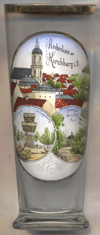
The Baroque  town church Sankt Margarethen [left, no. 0000: top picture]
was built in 1764 and includes elements of an earlier, late Gothic church.
town church Sankt Margarethen [left, no. 0000: top picture]
was built in 1764 and includes elements of an earlier, late Gothic church.
The bototm left picture shows a view of the
lookout tower
The bototm right picture shows a view of the
König-Albert-Turm
Further glasses in this collection show views from
Kirchberg am Wagram (Lower Austria),
Kirchberg am Wechsel (Lower Austria) and
Kirchberg an der Jagst (Baden-Württemberg, Germany).
[https://de.wikipedia.org/wiki/Kirchberg_(Sachsen);
https://www.deutsche-digitale-bibliothek.de/item/YQMIGQ63QXBUOLFX2HFQSSYGZQJW4JMV;
https://www.kirchberg.de/inhalte/stadt_kirchberg/_inhalt/kultur_tourismus/koenig_albert_turm/koenig_albert_turm]
![[scale]](lineal.jpg)