
|
|
| DEUTSCHLAND | GERMANY |
| Bundesland: Baden-Württemberg | |
| Regierungsbezirk: Tübingen | |
| Landkreis: Biberach |
map →

 Wain is situated at an elevation of 530 m about 20 km northeast of the district town
Biberach an der Riß, about 81 km southeast of the administrative centre of Baden-Württemberg's
administrative district Tübingen, and about 90 km southeast of Baden-Württemberg's capital,
Stuttgart. The municipality has a population of about 1,700 (2023).
Wain is situated at an elevation of 530 m about 20 km northeast of the district town
Biberach an der Riß, about 81 km southeast of the administrative centre of Baden-Württemberg's
administrative district Tübingen, and about 90 km southeast of Baden-Württemberg's capital,
Stuttgart. The municipality has a population of about 1,700 (2023).
Wain was first mentioned in a document in 1259. It was probably a high medieval clearing settlement in the Duchy of Swabia. In 1499, the town was sold to the count of Kirchberg, the heirs of whom transferred it to the Imperial abbey of Ochsenhausen in 1510. From 1570 to 1773 the town was under the control of the Free Imperial City of Ulm. In the course of the mediatisation, the Electorate of Baden initially took possession of Wain in 1805. However, the Kingdom of Bavaria laid claim to the dominion in accordance with the provisions of the Peace of Pressburg (Bratislava) and annexed it in 1806, so that Wain was Bavarian from 1806 to 1810. In 1810, Wain was ceded from Bavaria to the Kingdom of Württemberg due to the border treaty of 1810. Since 1939, Wain was part of the district Biberach.
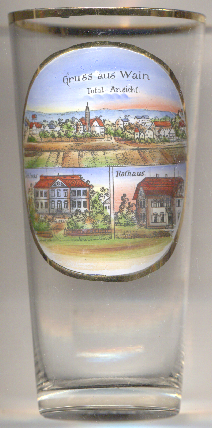
The Protestant  parish church of Sankt Michael [top picture: centre] was built in 1687, already as
a Protestant church. The tower was already built as part of the previous church.
parish church of Sankt Michael [top picture: centre] was built in 1687, already as
a Protestant church. The tower was already built as part of the previous church.
Wain manor [bottom left picture] was built in 1780/1781 in Classicist style based on designs by the
Munich court architect Lorenzo Quaglio.
The interiors were changed in the 18th/19th century.
The bottom right picture shows a view of the
[https://de.wikipedia.org/wiki/Wain;
https://de.wikipedia.org/wiki/St._Michael_(Wain);
https://de.wikipedia.org/wiki/Schloss_Wain]
town hall of Wain.
![[scale]](lineal.jpg) contact: webmaster
contact: webmaster