
|
|
| ÖSTERREICH | AUSTRIA |
| Bundesland: Tirol | Tyrol |
| Bezirk: Landeck |
map →

 The Rotpleiskopf (alternative spellings: Rothbleiskopf or Rothbleisskopf) (2.936 m) is a mountain in the
Samnaun mountain range of the Central Eastern Alps between the Paznaun and Inn valleys in the Landeck district of Austria's state of Tyrol.
The Rotpleiskopf (alternative spellings: Rothbleiskopf or Rothbleisskopf) (2.936 m) is a mountain in the
Samnaun mountain range of the Central Eastern Alps between the Paznaun and Inn valleys in the Landeck district of Austria's state of Tyrol.
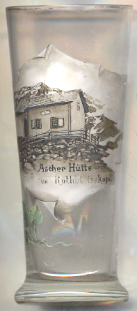
The mountain hut  Ascher Hütte, situated at an elevation of 2.256 m, was built in 1896 on the initiative
of the Section Asch (Aš) of the German Alpine Club. This first hut was not very big, but adequate
for the needs at the time. It had an anteroom and a stove in the living room for preparing hot meals. The section Asch could continue to
maintain the hut also during the period of the Czechoslovak Republic. After World War II the hut was
administered by the Austrian Alpine Club. The increasing number of visitors and regulatory requirements forced the section to carry out renovations
and extensions again and again. The first major renovation was carried out in 1957 and 1958, as the German Alpine Club had already agreed
in 1956 to provide funds for the renovation, despite the fact that the hut was still under the administration of the Austrian Alpine Club.
With the construction of a chairlift in 1972 from See to Medrigjoch (1.834 m), the ascent to the hut was significantly shortened, and thus
also to the surrounding peaks Rotpleiskopf, Blankakopf and the 3.004 m high Furgler. This resulted in a considerable increase in both day
and overnight guests. The resulting regulatory requirements for the expansion of the kitchen and toilets, as well as the construction of a new
sewage treatment plant, led to another major construction project, which was carried out in 1975 and 1976. Extensive expansions followed in
2010/2011.
Ascher Hütte, situated at an elevation of 2.256 m, was built in 1896 on the initiative
of the Section Asch (Aš) of the German Alpine Club. This first hut was not very big, but adequate
for the needs at the time. It had an anteroom and a stove in the living room for preparing hot meals. The section Asch could continue to
maintain the hut also during the period of the Czechoslovak Republic. After World War II the hut was
administered by the Austrian Alpine Club. The increasing number of visitors and regulatory requirements forced the section to carry out renovations
and extensions again and again. The first major renovation was carried out in 1957 and 1958, as the German Alpine Club had already agreed
in 1956 to provide funds for the renovation, despite the fact that the hut was still under the administration of the Austrian Alpine Club.
With the construction of a chairlift in 1972 from See to Medrigjoch (1.834 m), the ascent to the hut was significantly shortened, and thus
also to the surrounding peaks Rotpleiskopf, Blankakopf and the 3.004 m high Furgler. This resulted in a considerable increase in both day
and overnight guests. The resulting regulatory requirements for the expansion of the kitchen and toilets, as well as the construction of a new
sewage treatment plant, led to another major construction project, which was carried out in 1975 and 1976. Extensive expansions followed in
2010/2011.
[https://www.sudeten-huetten.de/?Asch/Ascher-Huette]
![[scale]](lineal.jpg)