
|
| BOSNA i HERCEGOVINA | BOSNIA and HERZEGOVINA |
| entitet: Република Српска / Republika Srpska | entity: Republic of Srpska |
| Regija: Власеница / Vlasenica |
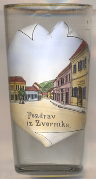
 Zvornik / Зворник is situated at an elevation of 146 m on the left bank of the river
Drina, which here marks the border between Bosnia and Herzegovina and Serbia, about 81 km northeast of Sarajevo.
The town has a population of about 12,700 (2013). Zvornik is the seat of the administration of the opština (municipality) Zvornik, which
has a population of 53,500 (2018).
The earliest known written document that mentions Zvornik dates from 1410. The town's geographic location has made it an important trade link
between Bosnia and the east. The main road connecting Sarajevo and Belgrade until today runs through the city.
The medieval fort known as Kula grad had already been built in the early 7th century and still stands on the Mlađevac mountainous range
overlooking the Drina valley. During the Ottoman period, Zvornik was the capital of the Sanjak of Zvornik within the Eyalet of Bosnia. The
Sanjak of Zvornik was one of six Ottoman sanjaks with most developed shipbuilding (besides the sanjaks of Vidin, Nicopolis, Požega,
Smederevo and Mohač). During Worls War II, Ustasha troops of the fascist Independent State of Croatia occupied Zvornik, along with
most of Bosnia, in April 1941. The town was liberated in July 1943 by the 1st Proletarian Brigade during the Battle of Zvornik. During the
Bosnian War (1992–1995) Zvornik's Bosniak population was expelled.
[https://de.wikipedia.org/wiki/Zvornik, https://en.wikipedia.org/wiki/Zvornik]
![[scale]](lineal.jpg)