
|
| POLSKA | POLAND |
| województwo: Wielkopolskie | voivodship: Greater Poland (Posnania) |
| powiat rawicki | county: Rawicz |
Rawicz is situated at an elevation of 117 m in the southwest of the Polish province of Greater Poland, about 89 km south of the provincial capital, Poznań. The municipality, capital of Rawicz county, has a population of about 30,300 (2020).
 The town was founded during the Thirty Years' War (1618–1648) for Protestant refugees from Silesia. In 1638 it gained the
privileges of a town. Rawicz was built as a precisely planned town and developed at a rapid pace as it was located on the trade route
connecting Poznań and Wrocław. In 1640, a cloth guild was founded. Cloth production became a
leading branch of the local industry, and by the end of the 18th century Rawicz was the leading weaving town of the whole region
of Greater Poland. After the destruction of Rawicz by the Swedes in 1655 during the 'Deluge', the town was rebuilt in an impressive way
in Baroque style. The early 18th century was an unfavorable period in the town's history. In 1701 it suffered a fire, in 1704–1705
it was occupied by Sweden, foreign troops marched through it: Russians in 1707, Austrians in 1719, Saxons in 1733, but in the following
decades rapid development took place again. In 1793, Rawicz was annexed by Prussia as a result of the Second Partition of Poland (see
map). In 1807 the town was recovered by Poles as part of the short-lived Duchy of Warsaw (see
map) and in 1815 it was again annexed by Prussia, initially as part of the autonomous Grand Duchy of
Posen (see map). After World War I, when Poland had regained its independence, the Battle of Rawicz
took place in 1919 as part of the Greater Poland uprising. Rawicz then became part of Poland again in 1920. Soon after the German
invasion of Poland in 1939 the first executions of Polish residents took place and mass expulsions of Poles folowed later in that year.
In January 1945, the town was taken over by the Soviets, who imprisoned soldiers of the Polish Home Army here.
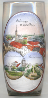
The Catholic parish  church of Christ the King and the Annunciation of the Blessed Virgin Mary
[left, no. 4661: top picture: centre] was built in 1900–1902 as the first Catholic church in a city dominated
at that time by Protestants. The design of the neo-Gothic building was made by the architect Alexis Langer. Originally, the church
was dedicated to the Annunciation of the Virgin Mary. In 1961 it was dedicated in addition to Christ the King.
The two lower pictures on glass no. 4661 show views labeled Kaiser-Friedrich-Promenade and Kaiserpromenade
('Emperor Promenade'). When the ramparts around the quadriateral old town were mostly removed in the late 19th century, the
western part of these were named Berliner Stadtgraben ('Berlin city moat') as it separted the old town from the
'Berliner Vorstadt', the suburb to the west (i.e. in direction of Berlin). Two monuments were erected
in the central part of the promenade, facing each other: the monument for Emperor Wilhelm I (unveiled on 19 June 1898)
and the  monument
[http://www.fallingrain.com/world/PL/86/Rawicz.html;
https://de.wikipedia.org/wiki/Rawicz, https://en.wikipedia.org/wiki/Rawicz;
https://pl.wikipedia.org/wiki/Ko%C5%9Bci%C3%B3%C5%82_Chrystusa_Kr%C3%B3la_i_Zwiastowania_Naj%C5%9Bwi%C4%99tszej_Maryi_Panny_w_Rawiczu;
https://www.profart.com.pl/wp-content/uploads/2020/08/04-5_Rawickie-planty.pdf]
![[scale]](lineal.jpg)