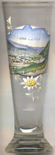

|
| ITALIA | ITALY |
| autonome Region: Trentino-Südtirol / regione autonoma: Trentino-Alto Adige | Trentino – South Tyrol |
| autonome Provinz: Bozen – Südtirol / provincia autonoma: Bolzano – Alto Adige |
 Lana is situated at an elevation of 272 m in the Etsch valley of northwestern South tyrol, about 7 km south of
Meran/Merano and about 20 km northeast of Bozen/Bolzano. The municipality
has a population of about 12,400 (2022).
The area must already have been inhabited in prehistoric times. The churches of St. Georg and St. Margarethen date back to the 9th century. The earliest known written document that mentions Loina dates from 1034. The lords of Lana already were in possession of the area in the 11th century. From the 13th century on, the family partitioned into several lines, such as the lords of Brandis, Lanaburg, Braunsberg, Marling-Lebenberg and Werrenberg. In 1396 Teutonic Order became in charge of the parish. Since the revival of the Order in 1855, the Teutonic Order House has been the seat of the Prior, the official of the Order's province of South Tyrol. In 1850, the previously independent municipalities of Vill, Oberlana and Niederlana were merged to form the present municipality of Lana.
Lana also was the former German name of Lány, Czech Republic.
[http://www.fallingrain.com/world/IT/17/Lana.html;
https://de.wikipedia.org/wiki/Lana, https://en.wikipedia.org/wiki/Lana,_South_Tyrol]
![[scale]](lineal.jpg)