
|
| ČESKÁ REPUBLIKA | CZECH REPUBLIC |
| Ústecký kraj | Ústí nad Labem region |
| Okres: Děčín |
 Verneřice is situated at an elevation of 493 m in the valley of the stream Bobří potok in the northeast of the
Bohemian Low Mountains (České středohorý) about 14 km southeast of the district town
Děčín and about 18 km east of the regional capital, Ústí nad Labem.
The municipality has a population of about 1,200 (2023).
Wernhersdorf (literally Wernher's village), a German settlement, was first mentioned in a written document dating from 1384. The village soon developed into a small town and received its first privileges in 1497. The right for having a crest and seal was granted in 1522. During the industrialisation of the end of the 18th century, several manufactories and factories were founded, such as the first Bohemian Cotton spinning mill in 1770. Due to the increase in economic importance, Wernstadt received full city rights in 1847. Tourism became another important economic factor in the early 20th century. After World War I, Wernstadt became part of the newly established Czechoslovakia. However, following the Munich Agreement of 1938, it was placed into the German-controlled Reichsgau Sudetengau region, district Tetschen-Bodenbach (Děčín), administrative region Aussig (Ústí nad Labem). After World War II, the German population was expelled and the town lost its status as a city. The status of a town was again granted in 2006.
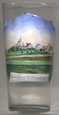
The  pilgrimage church Holy Trinity [left, no. 4631] on Boží vrch (Gottesberg, Lord's Hill)
was built in 1732–1733 by the Jesuit order. Two of the three houses next to the church were destroyed by fire in 1906. The church fell into dereliction
after World War II and was finally demolished in 1975.
[https://de.wikipedia.org/wiki/Verne%C5%99ice]
![[scale]](lineal.jpg)