
|
|
| DEUTSCHLAND | GERMANY |
| Bundesland: Niedersachsen | Lower Saxony |
| Landkreis: Harburg |
map →

 Moisburg is situated at an elevation of 15 m on the river Este northwest of the Lüneburger Heide nature reserve
in the district Harburg, about 35 km northwest of the district town Winsen (Luhe) (the district is named, for historical reasons, for the former city of
Harburg, today part of Hamburg). The municipality has a population of about 2,100 (2022) and is part of the Samtgemeinde
('collective municipality') Hollenstedt.
Moisburg is situated at an elevation of 15 m on the river Este northwest of the Lüneburger Heide nature reserve
in the district Harburg, about 35 km northwest of the district town Winsen (Luhe) (the district is named, for historical reasons, for the former city of
Harburg, today part of Hamburg). The municipality has a population of about 2,100 (2022) and is part of the Samtgemeinde
('collective municipality') Hollenstedt.
The earliest known mention of the place in a written documetn dates from 1242 and seems to refer to a castle. The area had been part of the county of Stade before it came in possession of the newly founded duchy of Braunschweig-Lüneburg in 1236. What we know today as (the former) Moisburg castle was only founded between 1310 and 1322 as a stronghold against the bishopric of Bremen. Until 1859 Moisburg was the administrative seat of the Amt (district) of the same name, thereafter it was part of the Amt Troisburg until 1885. Since then, it is part of the district Harburg.
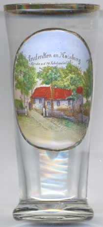
Glass no. 4621 [left] shows a view of the  village church of Moisburg. The labelling on the glass
describes it as Kirche a[us] d[em] 14. Jahrhundert ('church from the 14th century'). However, the oldest document
mentioning the church that is known today dates already from 1242 and parts of the walls of the church actually are from this period. The church was rebuilt
and extended in 1603–1616 as a chapel for Moisburg castle.
village church of Moisburg. The labelling on the glass
describes it as Kirche a[us] d[em] 14. Jahrhundert ('church from the 14th century'). However, the oldest document
mentioning the church that is known today dates already from 1242 and parts of the walls of the church actually are from this period. The church was rebuilt
and extended in 1603–1616 as a chapel for Moisburg castle.
[https://de.wikipedia.org/wiki/Moisburg;
https://de.wikipedia.org/wiki/Dorfkirche_Moisburg]
![[scale]](lineal.jpg)