
|
| FRANCE | FRANCE |
| région: Auvergne-Rhône-Alpes | |
| département: 74, Haute-Savoie |
 Vallorcine (in the past also spelled Vallorcines or Valorcine) is situated at an elevation of 1,9036nbsp;m in the département
Haute-Savoie, at the border to Switzerland, about 64 km northeast of the departmental capital, Annecy, and about 165 km
northeast of Lyon, the capital of the région Auvergne-Rhône-Alpes. As of January 2021, the municipality has a population
of 409.
Vallis Ursine was first mentioned in a written document in 1264. The place comes from the Latin words vallis (valley) and ursus (bear). The municipality changed from the canton of Saint-Gervais-les-Bains to the canton of Chamonix-Mont-Blanc in 1864 and became part of the canton of Le Mont-Blanc in 2015.
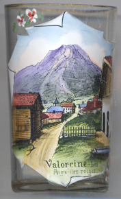
Depicted in the background are the  Aiguilles
[https://de.wikipedia.org/wiki/Vallorcine;
https://www.fallingrain.com/world/FR/B9/Vallorcine.html;
]
![[scale]](lineal.jpg)