
|
|
| ÖSTERREICH | AUSTRIA |
| Bundesland: Niederösterreich | Lower Austria |
| Bezirk: Hollabrunn |
map →

The oldest written mention of Maissau dates from 1114 and is in a document from the monastery of Klosterneuburg, which refers
to the donation of the local domains by the castellan of Mödling to the monastery.
[https://de.wikipedia.org/wiki/Maissau;
https://de.wikipedia.org/wiki/Burg_Maissau, https://de.wikipedia.org/wiki/Abensperg_und_Traun]
 Maissau is situated at an elevation of 341 m in the eastern slopes of the Manhartsberg mountain in the Weinviertel region of northern
Lower Austria, about 16 km west of the district town
Maissau is situated at an elevation of 341 m in the eastern slopes of the Manhartsberg mountain in the Weinviertel region of northern
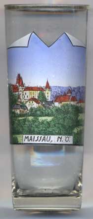
Lower Austria, about 16 km west of the district town  Maissau castle [left, no. 4610] was first mentioned in 1122. When the lords of Maissau in 1440
became extinct in the male line, the domains were inherited by the lords of Eckhartsau. Since 1526 it was in the possession of the lords of Traun
(1653 Imperial counts of Abensberg and Traun) and until today has remained in possession of the family. The stronghold with the keep was built in the
13th/14th century. The castle was expanded in the 16th and 17th centuries. Renovations were made around 1870 and were likely completed by 1879.
Maissau castle [left, no. 4610] was first mentioned in 1122. When the lords of Maissau in 1440
became extinct in the male line, the domains were inherited by the lords of Eckhartsau. Since 1526 it was in the possession of the lords of Traun
(1653 Imperial counts of Abensberg and Traun) and until today has remained in possession of the family. The stronghold with the keep was built in the
13th/14th century. The castle was expanded in the 16th and 17th centuries. Renovations were made around 1870 and were likely completed by 1879.
![[scale]](lineal.jpg) contact: webmaster
contact: webmaster