
|
| ÖSTERREICH | AUSTRIA |
| Bundesland: Niederösterreich | Lower Austria |
| Bezirk: Mödling |
 The earliest document mentioning Perchtoldsdorf dates from about 1140. The parish was
founded in 1217, and in 1308 the town is first mentioned as a market town.
Duke Albrecht II of Austria enlarged the castle around 1340. During the fight between the brothers Duke
Friedrich III and Duke Albrecht VI and the invasion of Hungarian troops under King
János Hunyadi in the 15th century the town suffered severe damages. When Emperor
Maximilian I (1493–1519) gained power the fortifications were improved and
the church fortress, but not the town itself, could thus withstand the invasion of
the Turks in 1529. Nevertheless, one sixth to one fifth of the population were killed
and almost the whole town was destroyed by the Turks in 1683. In the 18th century the
town gained popularity as a pilgrimage site (Leonhardikirche) and later as a wine growing area.
Between 1938 and 1945 Perchtoldsdorf was incorporated into the city of Vienna (Groß-Wien, Greater Vienna).


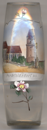
The  parish church Sankt Augustin [left] replaces an earlier chapel that was first mentioned in 1216.
The church in Gothic style was built in several periods in the 14th and 15th century.
The  Wehrturm or Türkenturm (Turks' tower, 60m high) [right] was part of the town's fortifications and has become the landmark of Perchtoldsdorf.
The lower parts of the tower were built between 1450 and 1460. Due to the times of war the construction was interrupted until 1518 and was completed in 1521/23.
The  Lady column (plague monument) [centre] dates from 1713/14 and includes a relief depicting the
plague in Vienna. This part is attributed to the great Baroque artist Johann Bernhard Fischer von Erlach.

![[scale]](lineal.jpg)