
|
| ČESKÁ REPUBLIKA | CZECH REPUBLIC |
| Plzeňský kraj | Plzeň region |
| Okres: Domažlice |
Klenčí pod Čerchovem (formerly in German: Klentsch; in Czech until 1945: Kleneč pod Čerchovem) is situated at an elevation of 497 m in the foothills of Čerchov (1,042 m), the highest mountain of the Český les mountains, about 9 km west of the district town Domažlice and about 54 km southwest of the regional capital Plzeň. The municipality has a population of about 1,300 (2019) and also includes the localities Capartice (Nepomuk), Černá Řeka (Sophienthal) and Jindřichova Hora (Heinrichsberg).
 The oldest known written document mentionng the place dates from 1325, the parish church was mentioned first in 1384. In the
18th century it belonged to the domains of Kauth (Kout na Šumavě) and Chodenschloss (Trhanov) in the district
Klattau (Klatovy). In 1850 it was reallocate to the district Taus (Domažlice).
In the 19th century, the period of the Czech National Revival, it was considered an 'advanced position' of Slavs, as it
was the westernmost settlement with a Czech-speaking majority of the population (compare language
map of the Austrian monarchy), while the villages of Capartice (Nepomuk), Jindřichova Hora (Heinrichsberg) and
Černá Reka (Sophienthal), today also part of the municipality, were predominantly German-speaking. During the
period of the German occupation (1940–1945) during World War II, it was part of the district
Waldmünchen. In 2006 it obtained the status of a městys (market town).
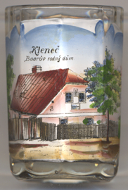
The picture on glass no. 3835 [left] shows the
 birth house
[https://de.wikipedia.org/wiki/Klenčí_pod_Čerchovem;
https://en.wikipedia.org/wiki/Jind&rcaro;ich_Šimon_Baar,
https://de.wikipedia.org/wiki/Jind&rcaro;ich_Šimon_Baar,
https://cs.wikipedia.org/wiki/Jind&rcaro;ich_Šimon_Baar]
![[scale]](lineal.jpg)