
|
| ČESKÁ REPUBLIKA | CZECH REPUBLIC |
| Středočeský kraj | Central Bohemia region |
| Okres: Nymburk |
 Lysá nad Labem is situated at an elevation of 183 m on the right bank of the river Labe about 14 km
west of the district town, Nymburk. The municipality has a population of about 9,700 (2019).
The place was first mentioned in the Cosmas Chronicle (1119–1125). Nová Lysá was first mentioned in 1291. In the 13th century, a castle was built here and until the reign of the Luxembourgs, the town was property of the Czech queens. Lysá was mentioned as a town as early as 1291. The town suffered heavily during the Hussite wars (ca. 1419–1434) and again during the Thirty Years' War (1618–1648). Lysá began to flourish again in the 17th century.
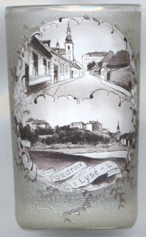
 Lysá caste [left, no.ฺ: background top left, and below, no. 4611: bottom picture: centre background]
dates back to the 11th century. Its first mention in a written document seems to date from 1052. In the 13th century
it was a Gothic castle with a moat and towers. The castle was destroyed during the Hussite Wars and was rebuilt in late Gothic
style thereafter. Following a fire in 1558 it was rebuilt in Renaissance style in 1560–1602. In the second half of the
17th century, the castle was remodeled in early Baroque style. the final redemoling in magnificent Baroque style was finished
in 1738–1739. Further remodelings, this time in Classicist style, took place around 1755 and in 1812–1815 (however,
parts of the southern wing were destroyed in 1862).

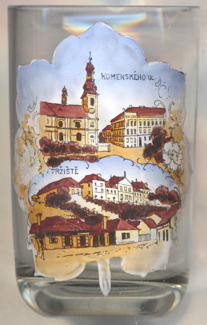
The  church of the Birth of St. John the Baptist [far left, no. 3642: background right,
near left, no. 4611, top picture: background, and below, no. 4625: top picture], the parish church of Lysá nad Labem, was built
in the first half of the 18th century and replaced the original Gothic parish church of the same dedication, which stood further east on the square
and was demolished in 1879.

The top picture on glass no. 4625 [near left] is labeled
 Komenského ul[ice]
The bottom picture is labeled  Tržiště
The former  Augustinian monastery [top background] goes back to the activities of the Augustinian order that had
been called into Lysá in the 14th century. The original monastery was destroyed by the Hussites in 1421 and nothing of it is left. The monastery
complex that we see today was built in the first half of the 18th century for the barefooted Augustinians. The convent was dissolved in 1812 and the
building was converted into a granary. Most of the complex is still preserved, but the former monastery church was demolished in 1891.
[https://de.wikipedia.org/wiki/Lysá_nad_Labem, https://en.wikipedia.org/wiki/Lysá_nad_Labem;
https://cs.wikipedia.org/wiki/Lysá_nad_Labem_(zámek);
https://cs.m.wikipedia.org/wiki/Kostel_Narození_svatého_Jana_Křtitele_(Lysá_nad_Labem);
https://cs.wikipedia.org/wiki/N%C3%A1m%C4%9Bst%C3%AD_B._Hrozn%C3%A9ho, https://cs.wikipedia.org/wiki/Bed%C5%99ich_Hrozn%C3%BD;
https://cs.wikipedia.org/wiki/Augustini%C3%A1nsk%C3%BD_kl%C3%A1%C5%A1ter_v_Lys%C3%A9_nad_Labem]
![[scale]](lineal.jpg)