
|
| SCHWEIZ / SUISSE / SVIZZERA / SVIZRA | SWITZERLAND |
| Waadt / Vaud / Vaud / Vad |
 Cottens is situated at an elevation of 579 m about 8 km northwest of the district town
Morges on an elevated plain near the river Morges in the west of the Swiss canton Vaud. The municipality has a
population of about 500 (2017).
Chotens was first mentioned in a written document dating from 1041. Since the Middle Ages it was the centre of a small dominion. When Vaud was conquered by Berne in 1536, Cottens was placed in the bailiwick of Morges. In 1789 it was placed in the district Cossonay, which was dissolved in 2008 and was divided among the districts Morges (with Cottens) and Gros-de-Vaud.
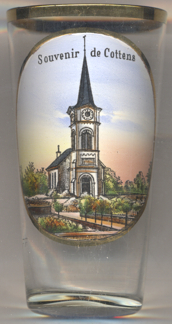
The Neo-Romanesque Protestant (Reformed)  parish church [left]
was built in 1893 in place of an older church of 1684. The architect was Francis Isoz.
[https://de.wikipedia.org/wiki/Cottens_VD, https://fr.wikipedia.org/wiki/Cottens_(Vaud),
https://fr.wikipedia.org/wiki/District_de_Cossonay]
![[scale]](lineal.jpg)