
|
| ČESKÁ REPUBLIKA | CZECH REPUBLIC |
| Královéhradecký kraj | Hradec Králové region |
| Okres: Rychnov nad Kněžnou |
 Rokytnice v Orlických horách is situated at an elevation of 580 m about 14 km east of
the district town Rychnov nad Kněžnou in the valley of the small river Rokytenka.
The municipality has a population of about 2,000 (2018).
Rokytnicz was first mentioned in 1318. In 1543 it was mentioned as a small town. In the second half of the 16th century it also officiallyy obtained the privileges of a small (market) town. After the end of manorialism in 1848/1849, Rokitnitz became an independent municipality within the district Senftenberg (Žamberk). In 1852 it obtained the status of a town. The local raiway from Rokitnitz to Daudleb (Doudleby) opened in 1906. In 1918 the German population declared its joining of the Province Sudetenland as part of German-Austria; however, the Czech Army occupied the town at the end of the same year. After the Munich Agreement of 1938 it became part of the German Reich (district Grulich (Králíky), Reichsgau Sudetenland (see map)). The German population was expelled in 1945 and Rokytnice lost its status as a town. In 1968 the town became a garrison of the Soviet Army. The status of a townn was reinstated in 1971. The Soviet Army left Rokytnice in 1991. Today, Rokytnice is a tourist centre in the Orlické hory (Adlergebirge) mountains.

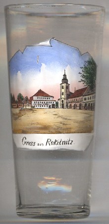
The  church of All Saints [left, no. 3534] is the Catholic parish
church of Rokytnice v Orlických horách. It is situated on a site of a wooden church of the 14th century
that had been destroyed by fire in 1661. The present church was rebuilt and enlarged in 1735&ndash1736. Donors from the
Czech Republic, Germany and Poland contributed to the reconstruction of the church in 1993–1999.
[https://de.wikipedia.org/wiki/Rokytnice_v_Orlických_horách,
https://cs.wikipedia.org/wiki/Rokytnice_v_Orlických_horách;
https://cs.wikipedia.org/wiki/Kostel_Všech_svatých_(Rokytnice_v_Orlických_horách)]
![[scale]](lineal.jpg)