
|
| ČESKÁ REPUBLIKA | CZECH REPUBLIC |
| Středočeský kraj | Central Bohemia region |
| Okres: Kladno |
 Kladno is situated at an elevation of 381 m about 25 km northwest of Prague in
the Central Bohemia region. Kladno is the largest city in the region and has a population of about 68,800 (2018).
Kladno was first mentioned in a document of 1318. In 1561 it obtained the status of a market town. For long it remained an insignificant rural community. This changed in the beginning of the 19th century when black coal was discovered in the area. From then on it began to develop into an industrial town. In 1870 it obtained the status of a town. The neighbouring communities of Vrapnice and Švermov were incorporated into Kladno in 1950 and 1980, respectively. Until 2003 Kladno was the seat of the administration of the homonymous district. With the administrative reform of 2003, all districts of the Czech Republic were dissolved as administrative units. In 2000, Kladno obtained the status of a statutory city.
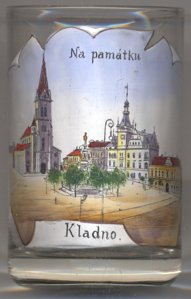
The  church of the Ascension of Our Lady [left, no. 3533: left]
was built in 1900 in Romanesque revival style in place of an earlier church from the 14th century.
The  town hall [left, no. 3533: right]
was built in 1897–1898 in Renaissance revival style.
The  Marian column [left, no. 3533: centre]
was built in 1739–1741 by the sculptor Karl Joseph Hiernle following a design of the famous architect Kilian Ignaz
Dientzenhofer.
[https://de.wikipedia.org/wiki/Kladno, https://en.wikipedia.org/wiki/Kladno, https://cs.wikipedia.org/wiki/Kladno]
![[scale]](lineal.jpg)