
|
|
| MAGYARORSZÁG | HUNGARY |
| megye: B6aacute;cs-Kiskun |
map →

Kecskemét is situated at an elevation of 122 m in the centre of the Kiskunság region, about 86 km southeast of Budapest and about the same distance northwest of Szeged. Kecskemét is the capital of the Bács-Kiskun county; the municipality has a population of about 111,700 (2016), this being the country's third-largest city (after Budapest and Szeged).
The first archeological trace of a human in the area is about five thousand years old. The Sarmatians invaded the area
in the first century B.C. While some historian believe that the settlement known as Partiskum of the Sarmatian
tribe, the Jazygians, was here, contemporary consensus rather is that prmanent settlement only occurred after the Hungarian
conquest. At the beginning of the 13th century, there were seven villages in the area, each with a population of
200–300 formed near the village church, a typical rural pattern. They were all destroyed by the Mongol Invasion.
As Kecskemét was situated at an important trading route, it grew as a customhouse and a market-place; in 1368 it
was identified as an oppidum (town) for the first time. During the Turkish invasion, Kecskemét had arranged
to pay tax directly to the pasha in Buda (today part of Budapest), thus gaining his protection and enjoying a special
situation. At the end of the 18th century, animal breeding started to decline in economic importance, as the fields had
become overgrazed and denuded. In the 19th century, Kecskemét was already part of an important wine district, but
 the city increased in importance after the vine-pest destroyed most vineyards in the hilly regions. The town's growth
suffered in the 1929–33 economic world crisis and Great Depression, followed by the upheaval and destruction of
World War II. During the war and especially May–June 1944, Hungarian authorities rounded up and deported most
of the Jews from the city to Auschwitz-Birkenau (Oświęcim, Poland), where most were killed. In 1950,
Kecskemét was made seat of the country's largest county, Bács-Kiskun.
the city increased in importance after the vine-pest destroyed most vineyards in the hilly regions. The town's growth
suffered in the 1929–33 economic world crisis and Great Depression, followed by the upheaval and destruction of
World War II. During the war and especially May–June 1944, Hungarian authorities rounded up and deported most
of the Jews from the city to Auschwitz-Birkenau (Oświęcim, Poland), where most were killed. In 1950,
Kecskemét was made seat of the country's largest county, Bács-Kiskun.
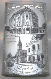
 Cifrapalota (Cifra Palace) [top picture], originally named
Városi bérház ('Town tenement house'), is a prominent example of Hungarian Art Nouveau
architecture, built in 1902 by architect Géza Márkus. Once there were shops, flats, commercial casinos,
today the Kecskemét Gallery is located here.
Cifrapalota (Cifra Palace) [top picture], originally named
Városi bérház ('Town tenement house'), is a prominent example of Hungarian Art Nouveau
architecture, built in 1902 by architect Géza Márkus. Once there were shops, flats, commercial casinos,
today the Kecskemét Gallery is located here.
The Orthodox Church [bottom picture: left], or Holy Trinity
Church, is the center of the Orthodox Christian faith in the city, one of the most important buildings in the city
centre. Greek families from the Turkish occupation arrived in Kecskemét since the end of the 17th century. At the
site of the former mosque, its bricks built the predecessor of today's church, which was soon expanding the community.
The present church was built between 1824 and 1829 in a classicist style according to plans by Ágoston Fischer
and his son.
The Industrial House [bottom picture: left], located next to the Orthodox
church, was built in 1906 by architects Marcel Komor and Dezső Jakab, also in Art Nouveau style.
[https://de.wikipedia.org/wiki/Kecskemét, https://en.wikipedia.org/wiki/Kecskemét;
https://en.wikipedia.org/wiki/Kiskunság;
https://hu.wikipedia.org/wiki/Cifrapalota;
https://hu.wikipedia.org/wiki/Magyar_ortodox_templom_(Kecskemét);
https://hu.wikipedia.org/wiki/Iparosotthon]
![[scale]](lineal.jpg)