
|
| DEUTSCHLAND | GERMANY |
| Bundesland: Baden-Württemberg | |
| Regierungsbezirk: Stuttgart | |
| Landkreis: Esslingen |
 Esslingen am Neckar is situated at an elevation of 241 m on the river Neckar about 14 km southeast of
Stuttgart. The municipality has a population of about 93,000 (2017) and is the seat of the
administration of the district Esslingen.
Ezelinga was fist mentioned in 777 AD. Around 800 the village became a market town with its rights being certified in 866. The town received important rights in 1181, which made it immediate to the empire; the city rights were first mentioned in 1229. During the same period the still extant Neckar bridge was built, making Esslingen a major centre for trade on the route between Italy, Switzerland, and northern Germany. For centuries the free imperial town was in conflict with the counts (later dukes) of Württemberg. Esslingen lost its status of Free Imperial Town in 1802 when it was incorporated into the Duchy (1806 Kingdom) of Württemberg. The beginning of the 19th century was characterised by industrialisation. Glove manufacturing, food processing, textiles, and metal working were early industries in Esslingen. In 1845 the first train ran from Cannstatt (today part of Stuttgart) to Esslingen, the line being part of the projected railroad connecting Ludwigsburg with Stuttgart and Esslingen. During World War II the city suffered very little damage, thus the medieval character of its city centre has been mostly preserved. In 1973 Nürtingen district was merged with Esslingen am Neckar, making Esslingen the seat of a much enlarged district.
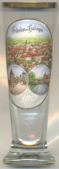
The Protestant  town church Sankt Dionys [top picture: centre]
is located on a site where a first church dedicated to St. Vitalis had been built around 700. A second, larger,
church, again dedicated to St. Vitalis, was erected in the 9th century. Until the 12th century it was enlarged
several times and also received the southern tower. When this church, being the parish church of Esslingen, in 1213
was donated to the cathedral chapter of Speyer, it was decided to replace it with a new
church building. Construction started around 1220/1230 and was completed in 1352. Around 1360/1370 the towers were
in danger of collapsing. Therefore the ground-floor halls of the towers, which had formed the transept of the church,
were cloased off by walls in order to support the towers. The northern portal had to be closed off in 1437 because
the northern tower still had been unstable. The two-storey sacristy was added around 1450.
The southern tower later on began to lean over to the south (about 56 cm)
so that in 1643–1650 two wooden bridges with iron chains connecting the two towers were constructed (the lower
bridge was removed in 1859, the upper bridge was replaced in 1900 by a steel construction with a wooden casing.
The  Schelztor [lower left picture] is one of three gate towers
remaining from the medieval fortifications from 1228 and is situated at the northwestern corner of the inner city.
the tower was renovated in 1993.
The  Maille [lower right picture]
is a popular park in Esslingen. The name is derived from the fact that this flat area between two Neckar channels
(Rossneckar and Wehrneckar) was originally used in the 17th century for the then popular Paille-Maille game. A city map
from 1739 already shows a network of paths and alleys. Chestnut, linden and walnut trees were planted along the alleys
in 1751/52. A sycamore alley was added in 1900.
[https://de.wikipedia.org/wiki/Esslingen_am_Neckar; https://en.wikipedia.org/wiki/Esslingen_am_Neckar;
https://de.wikipedia.org/wiki/Stadtkirche_St._Dionys_(Esslingen_am_Neckar);
http://www.esslingen-bilderbuch.de/stadtbefestigung/schelztor/index.php, https://de.wikipedia.org/wiki/Sehenswürdigkeiten_der_Stadt_Esslingen_am_Neckar;
https://de.wikipedia.org/wiki/Maille_(Esslingen_am_Neckar)]
![[scale]](lineal.jpg)