
|
| DEUTSCHLAND | GERMANY |
| Bundesland: Rheinland-Pfalz | Rhineland-Palatinate |
| Stadt: Landau in der Pfalz |
 Landau in der Pfalz is situated at an elevation of 142 m in the southern Weinstraße (Wine Route) area
of southern Rhineland-Palatinate. The municipality has a population of about 46,000 (2016) and also includes the town
districts Arzheim, Dammheim, Godramstein, Mörlheim, Mörzheim, Nußdorf, Queichheim and Wollmesheim.
Although itself independent from the sourrounding district, it is the seat of the administration of the district
Südliche Weinstraße (Southern Wine Route).
Landau was first mentioned in 1268, founded by the counts of Leiningen-Landeck. The town was granted a charter in 1274 by
German King Rudolf I who declared the town a Free Imperial Town in 1291. Nevertheless the Prince-Bishop of Speyer
seized the town in 1324. The town did not regain its ancient rights until 1511. From 1680 until 1815, Landau was part of
France, during which it was one of the Décapole, an alliance of ten towns of the Holy Roman Empire in Alsace
(Haguenau, Colmar, Wissembourg, Turckheim,
Obernai, Kaysersberg, Rosheim, Munster, Sélestat and Mulhouse, later also Seltz and Landau)
that had been founded in 1354. In 1688–1699 it received its modern fortifications by Louis XIV's military
architect Vauban, making the little town one of Europe's strongest citadels. In 1815 Landau, which had remained French,
was granted to the Kingdom of Bavaria and became the capital of one of the thirteen counties of the Bavarian
Rheinkreis, later renamed Pfalz, which in 1946 became part of Germany's state of Rheinland-Pfalz (Rhineland-Palatine).

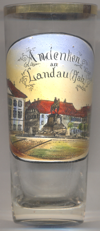
The  equestrian monument for Prince Regent Luitpold of Bavaria in Market Square (today
Rathausplatz) [left, no. 3428: centre] was created in 1892 by the sculptor Wilhelm von Rümann.
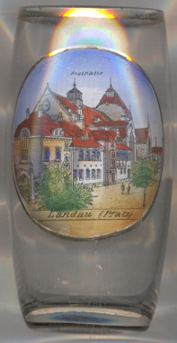
The  Festhalle (festival hall) [right, no. 3594] was built in
1905–1907 in Art Nouveau style. The architect was hermann Goerke, the portals were created by the sculptor
Gustav Adolf Bernd. The building is listed as an architectural monument and is one of the most important Art Nouveau
buildings in Germany.

Glass no. 3708 [near right] shows a view of the
 infantery
[https://de.wikipedia.org/wiki/Landau_in_der_Pfalz, https://en.wikipedia.org/wiki/Landau,
https://www.landau.de/Leben-Wohnen/Stadtportrait/Stadtgeschichte/Zeittafel;
https://de.wikipedia.org/wiki/Jugendstil-Festhalle]
![[scale]](lineal.jpg)