
|
|
| FRANCE | FRANCE |
| région: Pays de la Loire | |
| département: 44, Loire-Atalantique |
map →

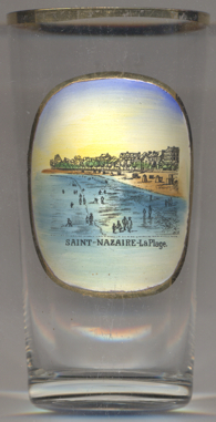 The harbour town Saint-Nazaire is situated on the right bank of the Loire River estuary, near the Atlantic Ocean.
The town is at the south of the second-largest swamp in France, called "la Brière". Saint-Nazaire is the
seat of the administration (chef-lieu) of the arrondissement Saint-Nazaire within the départment Loire-Atlantique.
The municipality has a population of about 70,000 (2015).
The harbour town Saint-Nazaire is situated on the right bank of the Loire River estuary, near the Atlantic Ocean.
The town is at the south of the second-largest swamp in France, called "la Brière". Saint-Nazaire is the
seat of the administration (chef-lieu) of the arrondissement Saint-Nazaire within the départment Loire-Atlantique.
The municipality has a population of about 70,000 (2015).
Archaeologists believe that Saint-Nazaire is built upon the remnants of Corbilo, an Armorican Gaulish city populated by the Namnetes tribe, which was the second-largest Gaulish city, after Massilia (now Marseille). Archeology suggests that the area has been inhabited since at least the Neolithic period, as evidenced by the presence of monuments like the tumulus of Dissignac and the dolmen located in the centre of the present-day city, and ancient bronzes found in the vicinity. According to the late-6th-century writer Saint Gregory of Tours, the the remains of the martyr Nazarius were sheltereed in a local basilica. After the end of the Hundred Years' War (1337–1453) Saint-Nazaire became a parish extending from Penhoët to Pornichet. Like the whole of Brittany, Saint-Nazaire was part of the Duchy of Brittany until 1532, when it was annexed by France. Until the French revolution, Saint-Nazaire belonged to the province of Brittany. At the beginning of the 19th century, the port only consisted of one simple harbour. In 1802, a roadway was built to develop the port, which extended by 1835, to a breakwater with a navigational lighthouse at its end. The development, included new basins for ships to unload to barges which carried goods further up the river. This development made the town the base for the passenger steamships of the Nantes–Saint-Nazaire line, as well as making the town the alternate port for ships which could not access Nantes. In 1856, the first wet-dock basin was dug in the handle of "Halluard City", making it possible for ships to moor and turn. This brought about the construction of the town's first railway connection. In 1868, Saint-Nazaire became a sub-prefecture in lieu of the town of Savenay. During World War I, the city became an important unloading port of the Allied troops, and particularly in the latter stages for the United States Army. During World War II, as part of Operation Ariel, Saint-Nazaire, like Dunkirk, became an evacuation point for the British back to England. Following the surrender of France to German forces in June 1940, the port immediately became a base of operations for the Kriegsmarine and was as such the target of Allied operations. A heavily fortified U-boat submarine base was built by Organisation Todt shortly after occupation, which with its 9-metre-thick concrete ceiling was capable of withstanding almost any bomb in use at the time. After the destructions caused by the war, Saint-Nazaire was rebuilt in the late 1940s in a minimalist functional style.
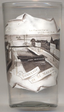
Glass no. 4668 [near left] shows a view of Saint Nazaire's outer port. The labeling (La Marseillaise et l'Amiral Aube')
refers to two batteships depicted in the background (but barely visible):
The armoured cruiser  Marseillaise was built at Brest, laid down in January 1900, launched in July 1901 and
finally completed in March 1903. During World War I it served in the Atlantic and took part in escort duty as part of the
Atlantic Squadron. She was taken off active service in 1929 and was subsequently broken up.
Marseillaise was built at Brest, laid down in January 1900, launched in July 1901 and
finally completed in March 1903. During World War I it served in the Atlantic and took part in escort duty as part of the
Atlantic Squadron. She was taken off active service in 1929 and was subsequently broken up.
The armoured cruiser Amiral Aube was built at Penhoet, laid down in 1899, launched in May 1902 and
finally completed in March 1904. It saw service in World War I and was finally taken off active service in 1922 and was
broken down subsequently.
[https://de.wikipedia.org/wiki/Saint-Nazaire, https://en.wikipedia.org/wiki/Saint-Nazaire;
https://2fwww.worldnavalships.com/marseillaise.htm;
https://2fwww.worldnavalships.com/amiral_aube.htm]
![[scale]](lineal.jpg)