
|
|
| DEUTSCHLAND | GERMANY |
| Bundesland: Baden-Württemberg | |
| Regierungsbezirk: Freiburg | |
| Landkreis: Ortenaukreis |
map →

Lahr / Schwarzwald is situated at an elevation of 170 m on the western edge of the Black Forest (Schwarzwald) where the Schutter Valley merges with the Upper Rhine River Plains from the east. The city of Lahr is made up of Lahr (proper) and the formerly independent communities of Burgheim (merged with Lahr in 1899) and Dinglingen (merged in 1933). Burgheim and Dinglingen have merged with Lahr also in a geographic sense. During the last major district reform in Baden-Württemberg in the 1970s Hugsweier, Kippenheimweiler, Kughbach, Langenwinkel, Mietersheim, Reichenbach and Sulz joined Lahr as new boroughs. The entire m unicipality has a population of about 44,900 (2015). On 1 October 1978 the official name of the town was changed from Lahr to Lahr / Schwarzwald.
 Lahr developed around the ‘Storchenturm’ (‘stork tower’) owned by the House of Geroldseck around
1220 and received a city charter around 1278. The charter was renewed in 1377 and served as the foundation for municipal
independence through to the end of the Hole Roman Empire. The city and surrounding land with the same name remained the
property of the Geroldsecks until 1426. Their successor was the House of Moers-Saarwerden, which
gave half the land to Baden as collateral for loans and in 1497 legal ownership was transferred
to it. The other half was transferred to the House of Nassau-Saarbrücken in 1522. Both Baden and
the House of Nassau-Saarbrücken implemented the Reformation in the areas under their control and ruled the city jointly
until the Baden half also became the property of the Nassaus in 1629. Dring the eighteenth century, the citizens of Lahr
sued the House of Nassau in the “Lahr Law Suits” in 1726 and 1778. The suits were decided in favor of the
citizens of Lahr and thwarted Nassau's attempt at absolute rule. As early as 1939 Lahr was the seat of the rural district
of the same name. During the Baden-Württemberg district reform in the 1970s the district was dissolved and its communities
were assigned and made part of the newly created Ortenau District.
Lahr developed around the ‘Storchenturm’ (‘stork tower’) owned by the House of Geroldseck around
1220 and received a city charter around 1278. The charter was renewed in 1377 and served as the foundation for municipal
independence through to the end of the Hole Roman Empire. The city and surrounding land with the same name remained the
property of the Geroldsecks until 1426. Their successor was the House of Moers-Saarwerden, which
gave half the land to Baden as collateral for loans and in 1497 legal ownership was transferred
to it. The other half was transferred to the House of Nassau-Saarbrücken in 1522. Both Baden and
the House of Nassau-Saarbrücken implemented the Reformation in the areas under their control and ruled the city jointly
until the Baden half also became the property of the Nassaus in 1629. Dring the eighteenth century, the citizens of Lahr
sued the House of Nassau in the “Lahr Law Suits” in 1726 and 1778. The suits were decided in favor of the
citizens of Lahr and thwarted Nassau's attempt at absolute rule. As early as 1939 Lahr was the seat of the rural district
of the same name. During the Baden-Württemberg district reform in the 1970s the district was dissolved and its communities
were assigned and made part of the newly created Ortenau District.
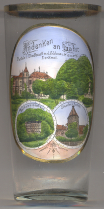
The  Stadtpark (municipal park) [top picture] was created by the industrialist
Christian Wilhelm Jamm who purchased the lot in 1859. The villa Bismarck
Stadtpark (municipal park) [top picture] was created by the industrialist
Christian Wilhelm Jamm who purchased the lot in 1859. The villa Bismarck
The Reichswaisenhaus ('Imperial orphanage') [bottom left picture]
is a villa which originally was built in 1855 as a silkworm breeding facility (hence its popular nickname at the time,
'silk palace'). In the 1870s, a nationwide donation call and further fund-raising activities raised the money for
the foundaton of the German empire's first Imperial orphanage. The building and premises were purchased in 1882 for the sum
of 40,000 Mark. In order to house 100 orphans, the building was enlarged and remodeled. the opening ceremony took
place on 25 May 1885.
The Storchenturm ('Stork Tower') [bottom right picture]
is the last remaining part or a medieval moated castle, and is the popular landmark of Lahr.
The castle had been founded by the House of Geroldseck around 1220. The Storchenturm was the norther tower
of the castle. Today it houses a museum on the castle's history.
[https://de.wikipedia.org/wiki/Lahr / Schwarzwald, https://en.wikipedia.org/wiki/Lahr;
https://de.wikipedia.org/wiki/Stadtpark_Lahr, http://www.stadtparklahr.de/index.php?article_id=20&clang=0;
http://www.badische-zeitung.de/lahr/skulpturen-in-lahr-die-verehrung-des-eisernen-kanzlers--89427451.html;
http://die-kleinen-strolche-lahr.jimdo.com/strolche/unser-haus/;
https://de.wikipedia.org/wiki/Storchenturm_Lahr]
![[scale]](lineal.jpg)