
|
|
| DEUTSCHLAND | GERMANY |
| Bundesland: Niedersachsen | Lower Saxony |
| Landkreis: Leer |
map →

 Leer is situated at an elevation of 3 m where on the rivers Leda and Ems. The old town was founded at a loop of the river Leda a short distance upstream of where
it flows into the Ems. Leer is the capital of the district of the same name. The municipality has a population of about 33,900 (2012) and thus is the third-largest
of the East Frisia region.
Leer is situated at an elevation of 3 m where on the rivers Leda and Ems. The old town was founded at a loop of the river Leda a short distance upstream of where
it flows into the Ems. Leer is the capital of the district of the same name. The municipality has a population of about 33,900 (2012) and thus is the third-largest
of the East Frisia region.
There are many traces of early settlements in the area, including crude flint tools that are dated back to the 3200 BC. In 791 AD Saint Ludger built the first chapel in East Frisia at the western edge of the settlement Leer, then still named Hleri after feetlot, willow. This chapel is mentioned for the first time in a written document from 850 AD. During the 14th and 15th centuries, Leer was home town of the Ukena family which was one most influential East-Frisian chieftain families of that time. The town profited from the trade with the Hanse, and a fortress Leerort was built. The right to have a market was obtained in 1508. In 1744 East Frisia fell to Prussia. Town privileges were awarded in 1823 by George IV, King of Hannover. In 1854 Leer became connected to the "Hannoversche Westbahn" railway, which at that time connected Emden and Rheine in the Ruhr area. In 1856 this railroad was connected to the central German railway network. Unlike Emden, Leer only suffered little damage by Allied bombing in World War II. In 1955 Leer ontained the status of an independent city.
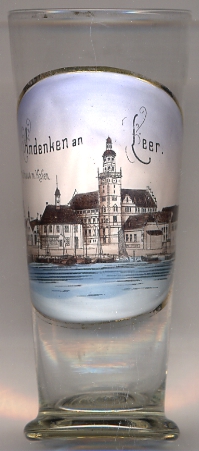
The  town hall was built in 1894 and was designed in Dutch Renaissance style by the architect Karl Henrici.
The adjacent Waage
town hall was built in 1894 and was designed in Dutch Renaissance style by the architect Karl Henrici.
The adjacent Waage
[https://de.wikipedia.org/wiki/Leer_(Ostfriesland), https://en.wikipedia.org/wiki/Leer]
![[scale]](lineal.jpg)