
|
|
| СРБИЈА SRBIJA | SERBIA |
| округ: Град Београд – okrug: Grad Beograd | district: City of Belgrade |
map →

Zemun (Hungarian: Zimony, German: Semlin) is located on the right bank of the Danube a short distance upstream of where the Sava flows into the Danube. Zemun is one of the seventeen municipalities which constitute the City of Belgrade. For most of its history, it developed separately from Belgrade, which lies across the Sava river, but the development of New Belgrade in the late 20th century joined them together in a continuous urban area.
In ancient times, the Celtic and Roman settlement was known as Taurunum. The Frankish chroniclers of the Crusades mentioned it as Mallevila, a toponym from the 9th century. This was also a period when a Slavic name Zemln was recorded for the first time. Believed to be derived from the word 'zemlja', meaning 'earth', it was a basis for all other future names of the city: modern Serbian Земун (Zemun), Hungarian Zimony and German Semlin.
 The first Celtic settlements in Taurunum area originate from the 3rd century BC when the Scordisci occupied several Thracian and Dacian areas of the
Danube. The Romans came in the 1st century BC, Taurunum became part of the Roman province of Pannonia around 15 AD. After the Great Migrations
the area was under the authority of various peoples and states, including the Byzantine Empire, the Kingdom of the Gepids and the Bulgarian Empire. The
town was conquered by the Kingdom of Hungary in the 12th century. After the nearby Serbian Despotate fell to the Ottoman Empire in 1459, Zemun became
an important military outpost. It was then conquered by the Ottomans in 1521. In 1541, Zemun was integrated into the Syrmia sanjak of the Budin pashaluk.
Zemun and the southeastern Syrmia were conquered by the Austrian Habsburgs in 1717, after the Ottoman defeat at the Battle of Peterwardein
(Petrovaradin) (5 August 1716) and through the Treaty of Požarevac (German: Passarowitz) of 1718. Its strategic
location near the confluence of the Sava and the Danube placed it in the center of the continued border wars between the Habsburg and the Ottoman empires.
The Treaty of Belgrade of 1739 finally fixed the border, the Military Frontier was organized in the region in 1746, and the town
of Zemun was granted the rights of a military commune in 1749. Zemun prospered as an important road intersection and a border city. During the Revolution
of 1848–1849, Zemun was one of the de facto capitals of Serbian Vojvodina, a Serbian autonomous region within Habsburg Empire, but in 1849, it
was returned under the administration of the Military Frontier. With the abolishment of the Military Frontier in 1882, Zemun and the rest of Srem was
included into Syrmia County of Croatia-Slavonia, which was an autonomous part of the Kingdom of Hungary and Austria-Hungary. During the World War I
in 1914, Zemun changed hands between Serbia and Austria-Hungary, finally ending up in Serbia in November 1918. The town became part of the Kingdom of Serbs,
Croats and Slovenes (later Kingdom of Yugoslavia). Following the surrender of Yugoslavia in 1941, Zemun, along with the rest of Syrmia, was given to the
Independent State of Croatia. The city was liberated from Axis occupation in 1944, and since then, it is part of the Serbian region known as Central Serbia.
[http://en.wikipedia.org/wiki/Zemun]
The first Celtic settlements in Taurunum area originate from the 3rd century BC when the Scordisci occupied several Thracian and Dacian areas of the
Danube. The Romans came in the 1st century BC, Taurunum became part of the Roman province of Pannonia around 15 AD. After the Great Migrations
the area was under the authority of various peoples and states, including the Byzantine Empire, the Kingdom of the Gepids and the Bulgarian Empire. The
town was conquered by the Kingdom of Hungary in the 12th century. After the nearby Serbian Despotate fell to the Ottoman Empire in 1459, Zemun became
an important military outpost. It was then conquered by the Ottomans in 1521. In 1541, Zemun was integrated into the Syrmia sanjak of the Budin pashaluk.
Zemun and the southeastern Syrmia were conquered by the Austrian Habsburgs in 1717, after the Ottoman defeat at the Battle of Peterwardein
(Petrovaradin) (5 August 1716) and through the Treaty of Požarevac (German: Passarowitz) of 1718. Its strategic
location near the confluence of the Sava and the Danube placed it in the center of the continued border wars between the Habsburg and the Ottoman empires.
The Treaty of Belgrade of 1739 finally fixed the border, the Military Frontier was organized in the region in 1746, and the town
of Zemun was granted the rights of a military commune in 1749. Zemun prospered as an important road intersection and a border city. During the Revolution
of 1848–1849, Zemun was one of the de facto capitals of Serbian Vojvodina, a Serbian autonomous region within Habsburg Empire, but in 1849, it
was returned under the administration of the Military Frontier. With the abolishment of the Military Frontier in 1882, Zemun and the rest of Srem was
included into Syrmia County of Croatia-Slavonia, which was an autonomous part of the Kingdom of Hungary and Austria-Hungary. During the World War I
in 1914, Zemun changed hands between Serbia and Austria-Hungary, finally ending up in Serbia in November 1918. The town became part of the Kingdom of Serbs,
Croats and Slovenes (later Kingdom of Yugoslavia). Following the surrender of Yugoslavia in 1941, Zemun, along with the rest of Syrmia, was given to the
Independent State of Croatia. The city was liberated from Axis occupation in 1944, and since then, it is part of the Serbian region known as Central Serbia.
[http://en.wikipedia.org/wiki/Zemun]
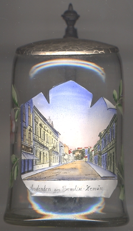
The picture on glass no. 2745 is not labelled but, by comparison with old postcards, the location could be identified as a view of
 Glavna
![[scale]](lineal.jpg)