
|
|
| DEUTSCHLAND | GERMANY |
| Bundesland: Freistaat Bayern | Bavaria |
| Regierungsbezirk: Niederbayern | |
| Landkreis: Regen |
map →

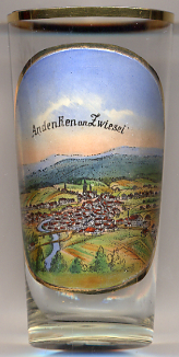 Zwiesel is situated at an elevation of 585 m in Bavaria's district of Regen at the confluence of the rivers Kleiner Regen and
Großer Regen which here form the river Schwarzer Regen. Zwiesel lies about 10 km northeast of the district town Regen, about
96 km northeast of Landshut, the administrative centre of the Bavarian administrative region Niederbayern
(Lower Bavaraia), and about 157 km northeast of the Bavarian capital, Munich. The municipality has a population
of about 9,100 (2025) and consists of the borroughs Ableg, Bärnzell, Glasberg, Griesbach, Innenried, Klautzenbach, Lichtenthal, Rabenstein,
Theresienthal, Zwiesel and Zwieselberg.
Zwiesel is situated at an elevation of 585 m in Bavaria's district of Regen at the confluence of the rivers Kleiner Regen and
Großer Regen which here form the river Schwarzer Regen. Zwiesel lies about 10 km northeast of the district town Regen, about
96 km northeast of Landshut, the administrative centre of the Bavarian administrative region Niederbayern
(Lower Bavaraia), and about 157 km northeast of the Bavarian capital, Munich. The municipality has a population
of about 9,100 (2025) and consists of the borroughs Ableg, Bärnzell, Glasberg, Griesbach, Innenried, Klautzenbach, Lichtenthal, Rabenstein,
Theresienthal, Zwiesel and Zwieselberg.
The earliest written document mentioning Zwisel dates from 125a. As the place was located at trading route to Bohemia close to its border,
it soon became an important reloading place for goods. Already in 1313 it is mentioned as a market town. The town's coat of arms was granted by
Duke Albrecht V of Bavaria in 1560. The famous glass industry of Zwiesel was founded in 1421 (Rabenstein). Mining for alum, sulphates,
iron ores and other metals goes back until the 16th century. The famous Theresienthal crystal glassworks were founded in 1836, the Annathal
glassworks (later Schott-Werke, today Zwiesel Kristallglas) were founded in 1872. In 1904 Zwiesel obtained the status of a town.
[https://de.wikipedia.org/wiki/Zwiesel]
[https://de.wikipedia.org/wiki/Zwiesel]
![[scale]](lineal.jpg)