
|
| DEUTSCHLAND | GERMANY |
| Bundesland: Niedersachsen | Lower Saxony |
| Landkreis: Göttingen |
 Duderstadt is situated at an elevation of 180 m in the district Göttingen.
It is the center of the northern part of the Eichsfeld region ("Untereichsfeld").
The municipality has a population of about 22,100 (2008). Duderstadt is famous for its medieval appearance; about 600 houses, most of them half-timered,
are still preserved from this period.
The earliest document referring to the city dates from AD 929. In 947 the town came in possession of the monastery of Quedlinburg and remained part of its territory for 262 years. In 1237 Duderstadt was fieffed off to Landgrave Heinrich Raspe of Thuringia but only 10 years later was given to Otto ("das Kind", 'the Child'), first Duke of Braunschweig and Lüneburg and grandson of Heinrich the Lion, duke of Saxony and Bavaria. For about a century the town remained under the rule of the Guelphs. Duderstadt received a town charter around 1250. Between 1334 and 1366, the Guelph dukes of the Grubenhagen line gradually ceded the town to the archbishops of Mainz. For further 450 years the town then remained under the rule of the archbishops. Around 1400 Duderstadt had about the same size as Hamburg. The downfall of the Hanse federation and the concomitant diversion of trading routes, The Thirty Years' War (1618–1648) and the Seven Years' War (1756–1763) caused a gradual decline of the imprtance of the town. In the 19th century Duderstadt suffered by its location near the border between the Electorate Hannover and Prussia. Even when the first railroad line were built, Duderstadt remained far from the main lines. It took until 1887/89 that the city was connected to the railway lines from Wulften to Leinefelde, the Southern Harz railroad and the Halle-Kassel Railroad. After World War II the close proximity to the Iron Curtain caused yet another decline in the economical sitation. The district Duderstadt was united with the district Göttingen in 1973.
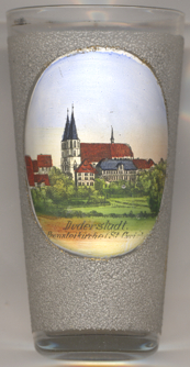
The Catholic  provost church of St. Cyriakus [left, no. 3782, and
below, no. 2583: background]
is located on a site that was already occupied by an earlier, Romanesque church.
The patronage of St. Cyriakus probably dates back to around AD 950.
Around 1250 the monumental westwork was added; however, the westwork at first had one tower only.
The Gothic choir was added in 1394, the Late Gothic nave was completed in 1490. The southern tower
was only added to the westwork in 1854. Treasures of the church are the winged altar in the chancel, dating from around 1500,
the Trinity altar of 1470, statues of the apostles from between 1600 and 1660., the baptismal font of 1694 and the organ dating from 1734.
 The
The  Town Hall [near left, no. 2583: right] is one of the oldest in Germany.
Its core originated around 1302/1303 as a two-storey merchants' hall. In 1432 the original town hall at the southwestern corner
was replaced by an annex to the merchants' hall. The typical half-timered upper storeys were added in the 16th century.
A roofed staircase with lifesized figures supporting its roofing was added in 1673/1674.
![[scale]](lineal.jpg)