
|
|
| DEUTSCHLAND | GERMANY |
| Bundesland: Freistaat Bayern | Bavaria |
| Regierungsbezirk: Oberbayern | |
| Landkreise: Starnberg, Bad Tölz-Wolfratshausen, Weilheim i. Ob. |
map →

| prev.: Würmsee |
 The lake Starnberger See in southern Bavaria is Germany's fourth largest lake and a popular recreation area for the nearby city of Munich.
Towns by the lake include Starnberg in the north, Seeshaupt in the south, and Tutzing in the west. The small town of Berg near Starnberg is famous
as the site where King Ludwig II of Bavaria drowned in the lake in 1886. Possenhofen on the western lakeshore was the site where princess Elisabeth in Bavaria,
the later wife of the Austrian Emperor Franz Joseph I, spent her youth.
The name Starnberger See officially replaced the older name Würmsee only in 1962. The name became popular from the late 19th century onward,
when the railroad from Munich to Starnberg was established.
The lake Starnberger See in southern Bavaria is Germany's fourth largest lake and a popular recreation area for the nearby city of Munich.
Towns by the lake include Starnberg in the north, Seeshaupt in the south, and Tutzing in the west. The small town of Berg near Starnberg is famous
as the site where King Ludwig II of Bavaria drowned in the lake in 1886. Possenhofen on the western lakeshore was the site where princess Elisabeth in Bavaria,
the later wife of the Austrian Emperor Franz Joseph I, spent her youth.
The name Starnberger See officially replaced the older name Würmsee only in 1962. The name became popular from the late 19th century onward,
when the railroad from Munich to Starnberg was established.
The lake, which was created by ice age glaciers from the Alps, extends 21 km (14 miles) from north to south and has a width of 3–5 km (2–3.5 miles) from east to west. It has a single, small island, the Roseninsel, and a single outlet, the Würm river (because of this river the lake was called the Würmsee until 1962). Its major inflow comes from a chain of small lakes in the south, Osterseen. This small river is called Ach or Ostersee-Ach.
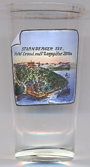
The picture on glass no. 2328 shows a view of the  Hotel Zugspitze
[Text adapted in part from http://en.wikipedia.org/wiki/Lake_Starnberg]
![[scale]](lineal.jpg)