
|
|
| DEUTSCHLAND | GERMANY |
| Bundesland: Brandenburg | |
| Landkreis: Ostprignitz-Ruppin |
map →

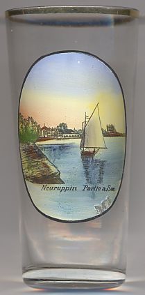 Neuruppin is situated at an elevation of 40 m at the western bank of the lake, Ruppinersee (Rhinsee).
The municipality has a population of about 32,100 (2005).
Neuruppin is situated at an elevation of 40 m at the western bank of the lake, Ruppinersee (Rhinsee).
The municipality has a population of about 32,100 (2005).
The earliest traces of human settlements in this area date back to the Mesolithic period and the early Bronze Age. Around 1214 a fortress was founded near an older Slavic stronghold and became the origin of Alt Ruppin. Neuruppin was founded by the counts of Lindow-Ruppin, a collateral line of the counts of Arnstein who resided in Alt Ruppin. The earliest written mention of the town dates from 2137. In 1256 Neuruppin was granted the status of a town. When the counts of Lindow-Ruppin became extinct in 1524 Neuruppin came in possession of the margraves of Brandenburg. In 1688 it became one of the earliest garrison towns in Brandenburg. When Crown Prince Friedrich (the later King Friedrich II, 'the Great') had served his sentence at Küstrin, heserved as commander here between 1732 and 1740. During the Thirty Years' War (1618–1648) the town was destroyed. In 1685 Huguenot refugees from France settled here. A large fire destroyed about two thirds of the town again in 1787. The town was rebuilt, on a regular ground plan, between 1788 and 1804. In 1993 the neighbouring communities of Alt Ruppin, Buskow, Gnewikow, Gühlen-Glienicke, Karwe, Krangen, Lichtenberg, Molchow, Nietwerder, Radensleben, Stöffin, Wulkow and Wuthenow were incorporated into the municipality of Neuruppin.
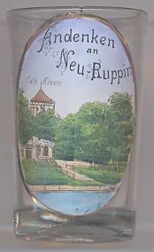
Glass no. 2323 shows a view of the  Café
Café
![[scale]](lineal.jpg)