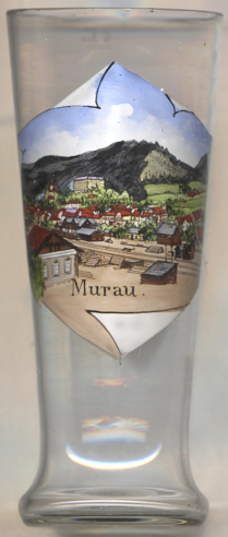

|
| ÖSTERREICH | AUSTRIA |
| Bundesland: Steiermark | Styria |
| Bezirk: Murau |
 The first settlements in the area of Murau are documented by archeological
finds from the Bronze Age. Further finds date from Roman times. Founded by the
Liechtenstein family (unrelated to the Princes of Liechtenstein),
the first documents mention the name in 1250. The town received
the freedom of the city in 1298. In the Middle Ages it was a trading place for iron and salt.
The formerly independent municipality of Stolzalpe
was incoporated into Murau on 1 January 2015.
Above the city, the castle  Schloss Obermurau [left, no. 210: top left]
was erected in 1628–1630 replacing the remainders of the old Liechtenstein castle.
The castle is owned by the Schwarzenberg family.
 The
The  parish church St. Matthäus [centre top]
dates from 1296 and contains frescoes from the 14th and 15th century and a crucifixion of around 1500.
The  Bahnhofbrücke ('Station Bridge') [near left, no.ɭ: foreground]
across the Mur river was built in 1897.
[https://www.historischerverein-stmk.at/wp-content/uploads/Z_SB03_Ernst-GASTEIGER-Chronologische-Darstellung-der-wichtigsten-Ereignisse-aus-der-Geschichte-der-Stadt-Murau.pdf]
The labelling on glass no. 621 [near left] actually contains a mistake: on the bottom it reads
Bahnhofbrücke

The view depicted on glass no. 4662 [near left] shows a panomaric view of Murau with the castle shown in the
background. In the foreground, the railroad tracks of the
 train station
![[scale]](lineal.jpg)