
|
|
| ČESKÁ REPUBLIKA | CZECH REPUBLIC |
| Plzeňský kraj | Plzeň region |
| Okres: Plzeň-jih |
map →

The
The building depicted on the right of glass no. 0000 is the
The building depicted in between the two aforementioned buildings in the background is the
[https://de.wikipedia.org/wiki/Dob%C5%99any;
https://mapy.com/de/zakladni?source=base&id=2319655&x=13.2907481&y=49.6562664&z=17]
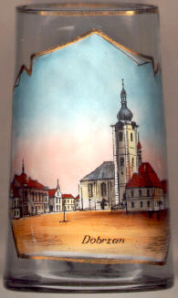 Dobřany is situated at an elevation of 352 m on the river Radbuza in West Bohemia. The place was first mentioned as a town in 1260.
The privileges granted by Emperor Rudolf II (1576–1612) were confirmed by Emperor Ferdinand III (1608–1657) in 1652.
The population was predominantly German from late 17th until the late 19th century; from then on the Czech population was in the majority.
The older German name of the town, Dobrzan, was replaced by the name Wiesengrund in 1938. In 1943 the town was severely damaged
by an air raid which was intended to hit the Škoda works in Plzeň.
Dobřany is situated at an elevation of 352 m on the river Radbuza in West Bohemia. The place was first mentioned as a town in 1260.
The privileges granted by Emperor Rudolf II (1576–1612) were confirmed by Emperor Ferdinand III (1608–1657) in 1652.
The population was predominantly German from late 17th until the late 19th century; from then on the Czech population was in the majority.
The older German name of the town, Dobrzan, was replaced by the name Wiesengrund in 1938. In 1943 the town was severely damaged
by an air raid which was intended to hit the Škoda works in Plzeň.
 parish church St. Nicholas [far left, no. 205, and near left,
no. 0000: left] was founded by the monastery of Tepl in 1259.
The Gothic church was remodelled in Baroque style in 1757–1758. The tower dates from 1694–1700.
town hall post office
parish church St. Nicholas [far left, no. 205, and near left,
no. 0000: left] was founded by the monastery of Tepl in 1259.
The Gothic church was remodelled in Baroque style in 1757–1758. The tower dates from 1694–1700.
town hall post office
![[scale]](lineal.jpg) contact: webmaster
contact: webmaster